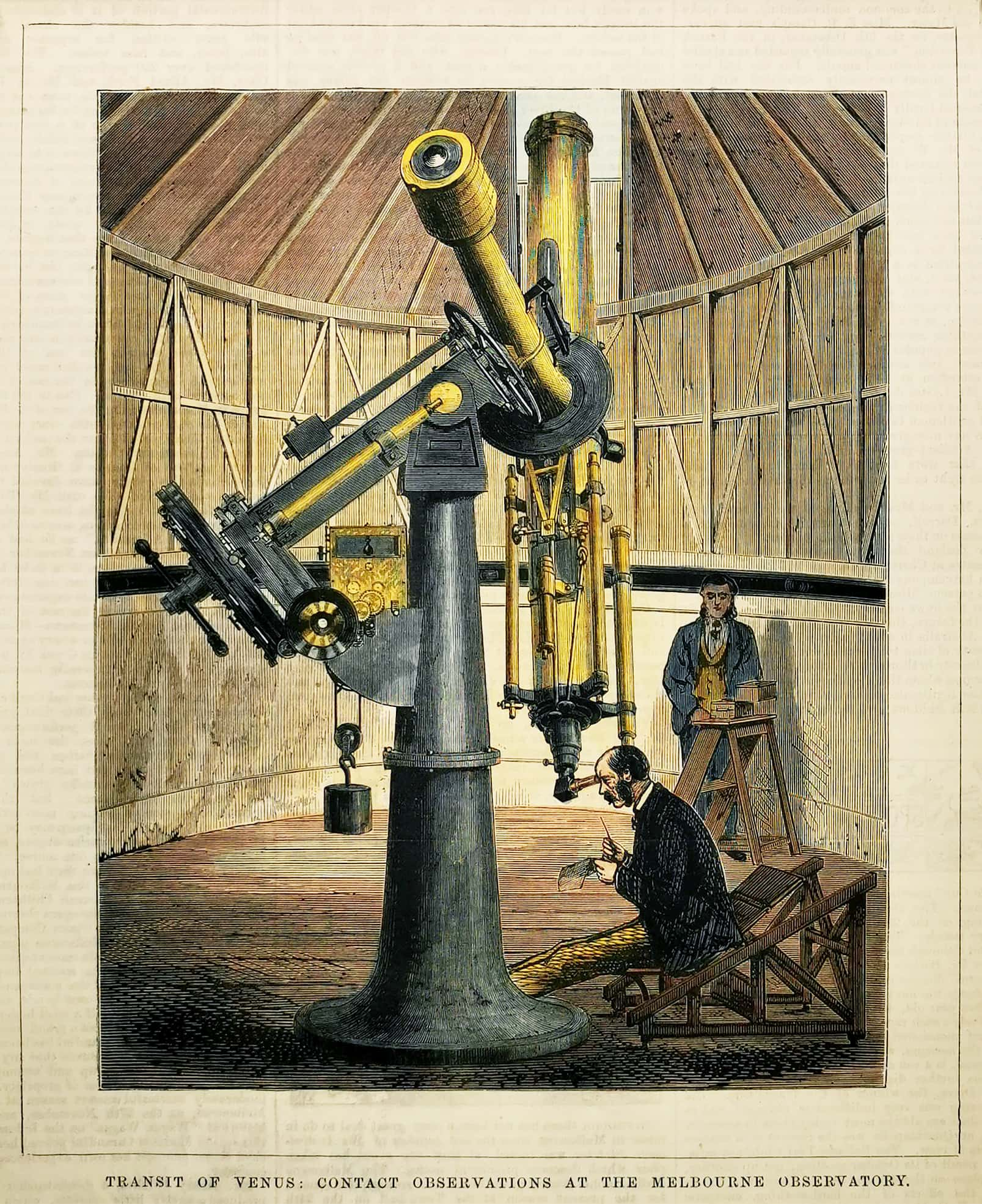
Transit of Venus: Contact Observations at the Melbourne Observatory.

Transit of Venus: Contact Observations at the Melbourne Observatory. Victoria - Melbourne

Scarce engraving of the Melbourne Observatory observing the Transit of Venus which took place on 9 December 1874 (01:49 to 06:26 UTC) . This was the first of the pair of transits of Venus that took place in the c.19th, with the second transit occurring eight years later in 1882. The previous pair of transits had taken place in 1761 and 1769 and which Cook’s first expedition was sent by the Royal Society to observe at Tahiti.

From the original edition of the Australasian Sketcher.

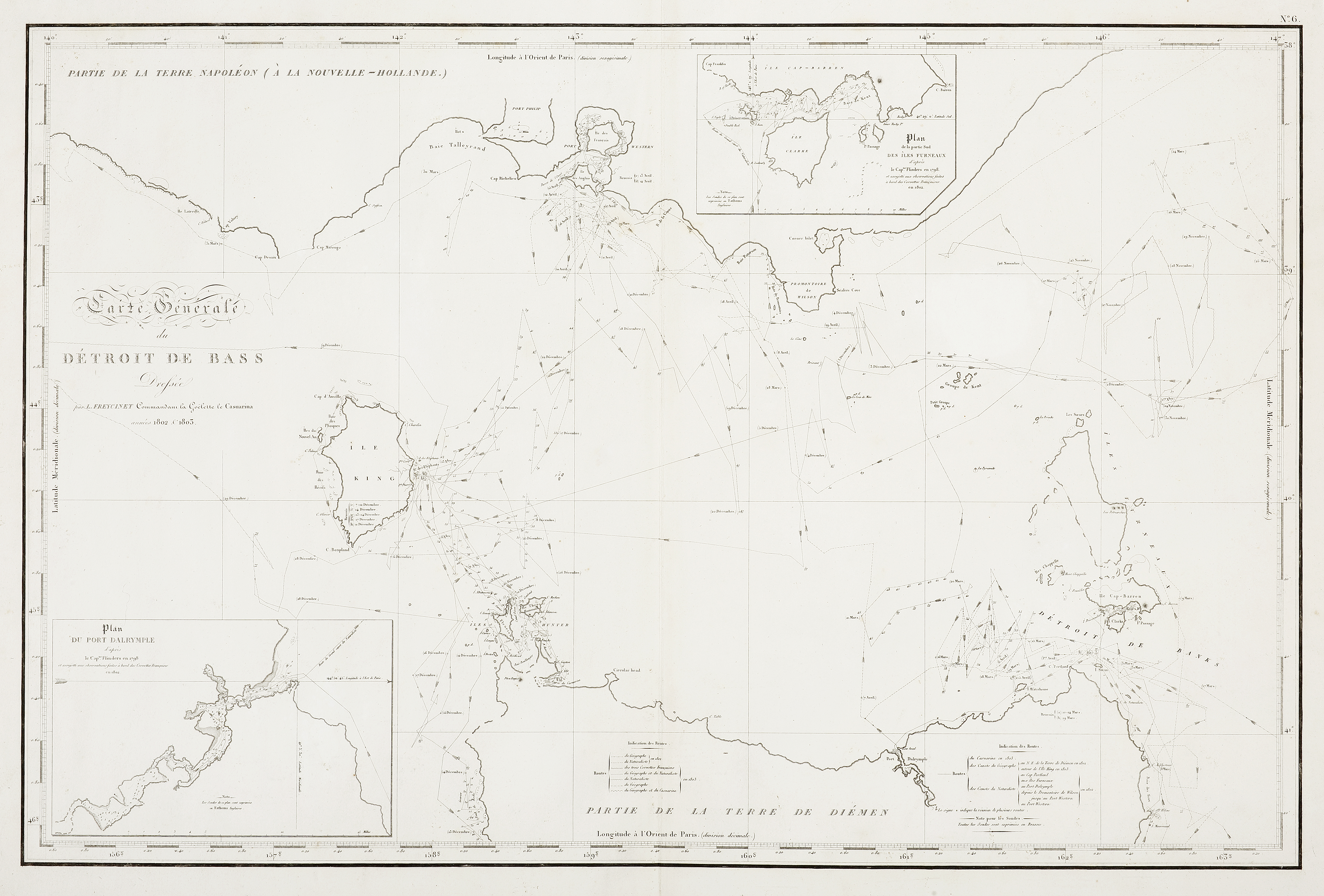
Carte generale du Detroit de Bass

Carte generale du Detroit de Bass Tasmania

Important French chart of Bass Strait showing the tracks of Le Geographe, Le Naturaliste and Le Casuraina in 1802 under the command of Captain Nicolas Baudin (1754-1803).

With two small inset charts after M. Flinders.
Insets: Plan du Port Dalrymple d’apres le Capne. Flinders en 1798 et assujetti aux onservations faites a bord des corvettes Francaises en 1802 — Plan de la partie sud des Iles Furneaux d’apres le Capne. Flinders en 1798 et assujetti aux observations faites a bord des corvettes Francaises en 1802.

Charting Tasmania;
Baudin reached Tasmania on 13 January 1802 and began chartingd the whole length of Tasmania’s east coast.

27 February 1802 The ships leave Maria Island and head north to continue the survey of the east coast of Tasmania
6 March 1802       The Geographe loses contact with a dinghy containing the geographer Boullanger, midshipman Maurouard and six sailors, sent to conduct a closer survey of the coast.
8 March 1802       Baudin confined to bed with colic pains; the two ships become separated during the evening
9 March 1802       Boullanger’s boat party picked up by an English brig, the Harrington; the Naturaliste encounters an English schooner, the Endeavour, which is heading for Maria Island
10 March 1802      The Geographe encounters the Endeavour; the Naturaliste encounters the Harrington at the entrance to Banks Strait and recovers Boullanger and his boat party; Hamelin begins survey of Bass Strait while waiting for the Geographe at Banks Strait (not at the agreed rendezvous point of Waterhouse Island)
11 March 1802      The Geographe breaks off its search for the lost dinghy and heads north
18 March 1802      The Naturaliste leaves Banks Strait to search for the Geographe to the south (along the east coast of Tasmania)
19 March 1802      The Géographe sights Waterhouse Island, the rendezvous point in Banks Strait, but the Naturaliste has just departed: the two ships have passed one another in the mists
24 March 1802     After several days of stormy weather and rough seas, the Geographe heads towards Wilson’s Promontory to begin its survey of the “unknown” south coast of New Holland

Charting of the Victorian coast;
The Geographe under Nicolas Baudin (1754-1803), sailing from Van Diemen’s Land, sighted the coast line of New Holland on 27 March 1802. After checking his position near Wilson’s Promontory on the chart he carried, one Flinders had made from the sketch map drawn by Bass after the whale-boat survey of 1798, Baudin proceeded along the coast (no more than a league from it) towards Western Port on the 28th March. The first bay they came to, they named Baie Paterson [Waratah Bay] ‘in honour of the worthy English scholar and traveller of that name, one of Mr. Bass’s most intimate friends’. The next day the Géographe coasted a second bay, which was named Baie de la Vénus ‘after a vessel commanded by Mr Bass’.  When Baudin came to what the chart named Western Port on 29 March he did not recognise the entrance, and sailed on. Returning the next morning to where he had ceased charting the previous day, he saw an opening that he now recognised as Western Port. Passing Cape Schanck he entered the bight where Port Phillip lies, but did not approach closely enough to see the entrance to Port Phillip.

Proceeding along the coast in a general south-westerly direction, Baudin named Cap de Représentations [probably Cape Patton], on account of various protests his staff had made to him at the time. By nightfall on 30 March the Géographe had reached Pointe de la Plate-forme [probably Cape Marengo].

The day’s run on 31 March, about four miles offshore, took the Géographe past Cap du Maréchal [probably Cape (Albany) Otway, [named by Grant]- so-named because at the top of an eminence on the shore one could see two cavities in exactly the shape of a horseshoe, and Cap des Falaises (cliffs) [probably Cape Volney], being the first point met after doubling Cap du Maréchal. At the end of the day the ship stood offshore for the night opposite a dominant hill near present-day Warrnambool that Freycinet later named Piton de Reconnoissance (Reconnaissance Peak). Next day, 1 April, Baudin examined Portland Bay: he named Lady Julia Percy Island Île aux Alouettes (larks)100 because they caught a skylark that had rested on the ship while they were level with the island, and Lawrence Rock he named Île du Dragon101 on account of its perfect resemblance, from both east and west, to the fabulous beast of that name. The Géographe reached what is now the Victorian/South Australian border on 2 April 1802. source anzmaps

27 February 1802 The ships leave Maria Island and head north to continue the survey of the east coast of Tasmania 6 March 1802 The Géographe loses contact with a dinghy containing the geographer Boullanger, midshipman Maurouard and six sailors, sent to conduct a closer survey of the coast 8 March 1802 Baudin confined to bed with colic pains; the two ships become separated during the evening 9 March 1802 Boullanger’s boat party picked up by an English brig, the Harrington; the Naturaliste encounters an English schooner, the Endeavour, which is heading for Maria Island 10 March 1802 The Géographe encounters the Endeavour; the Naturaliste encounters the Harrington at the entrance to Banks Strait and recovers Boullanger and his boat party; Hamelin begins survey of Bass Strait while waiting for the Géographe at Banks Strait (not at the agreed rendezvous point of Waterhouse Island) 11 March 1802 The Géographe breaks off its search for the lost dinghy and heads north 18 March 1802 The Naturaliste leaves Banks Strait to search for the Géographe to the south (along the east coast of Tasmania) 19 March 1802 The Géographe sights Waterhouse Island, the rendezvous point in Banks Strait, but the Naturaliste has just departed: the two ships have passed one another in the mists 24 March 1802 After several days of stormy weather and rough seas, the Géographe heads towards Wilson’s Promontory to begin its survey of the “unknown” south coast of New Holland 27 March 1802

The Géographe sights Wilson’s Promontory 29 March 1802 The Géographe leaves Wilson’s Promontory and follows the coast in a westerly direction 3 April 1802 The Naturaliste regains Waterhouse Island after its unsuccessful search for the Géographe around Maria Island; Hamelin undertakes further survey work (Port Dalrymple) 7 April 1802 Hamelin leaves Tasmania and heads for the northern side of Bass Strait; a boat party is sent to fix the position of Wilson’s Promontory and chart the coast from there to Western Port; other boat parties are sent to examine Western Port itself 8 April 1802 The Géographe meets the Investigator, commanded by Matthew Flinders, in Encounter Bay (named by Flinders to commemorate this meeting) 9 April 1802 Flinders visits the Géographe for a second meeting with Baudin, before the ships part ways, Flinders following the coast in an easterly direction, Baudin entering Backstairs Passage to begin his survey of the north coast of Kangaroo Island and of the two gulfs north of it 18 April 1802 Hamelin leaves Bass Strait and heads for Port Jackson.

From Peron, Voyage de decouvertes aux terres australes … : partie navigation et geographie. Paris 1811


Tereoboo, King of Owyhee, bringing Presents to Capt. Cook.

Tereoboo, King of Owyhee, bringing Presents to Capt. Cook. PACIFIC ISLANDS

Spectacular and important engraving depicting the Big Island high chief, Kalaniopuu, identified as Tereoboo in the title of this engraving, in transit on his way to visit Cook aboard the Resolution, which had laid anchor in Kealakekua Bay on 27 January 1779.

Tereoboo, was a king of the island of Kauai, one of the Hawaiian islands, during the 18th century. He was a leader of the island during the time of Captain James Cook’s third and final voyage to the Pacific in 1778. Tereoboo is known for his interactions with Captain Cook and his crew as he was among the first Hawaiian leaders to make contact with Western explorers, and his visit with Cook and his crew helped to establish relationships between the Hawaiian people and European explorers. Although, Tereoboo is not widely known outside of historical records of Captain Cook’s voyage, he played an important role in the history of Hawaii and the encounter of the Hawaiian people with the Western world.

He is portrayed in a feather cloak, standing toward the front of the lead outrigger. He is accompanied by a number of kahuna, or temple priests, including the high priest, Kao. Gifts of pigs and produce are carried in the canoe to right of the lead canoe. The canoe in the left foreground carries four temple images.’ Cook Journals III, i, 512.

‘At noon on January 26, 1779, Tereoboo, in a large canoe attended by two others, set out from the village and paddled towards the ships in great state. As they went along, those in the center canoe kept singing with much solemnity, from which we concluded that the procession had some of their religious ceremonies mixed with it. But instead of going on board, they came to our side. Their appearance was very grand.’

The significance of this engraving is that it represents one of the earliest recorded encounters between Western explorers and the Hawaiian people. It also serves as an important historical record of the interactions between the two cultures and the island of Hawaii during the 18th century. Cook’s interactions with the Hawaiian people were important for his journal and his voyage, as it helped him to understand the culture and customs of the islanders.

This engraving is from the official British Admiralty sanctioned edition of the accounts of Cook’s third and final voyage. All other later copies made of this image by other publishers were unauthorised, usually smaller and inferior in quality.

Beddie 1743-61, p.342, Joppien 3.298A, ill.p.530

From Cook & King, A Voyage to the Pacific Ocean Undertaken by the Command of His Majesty, for Making Discoveries in the Northern Hemisphere….

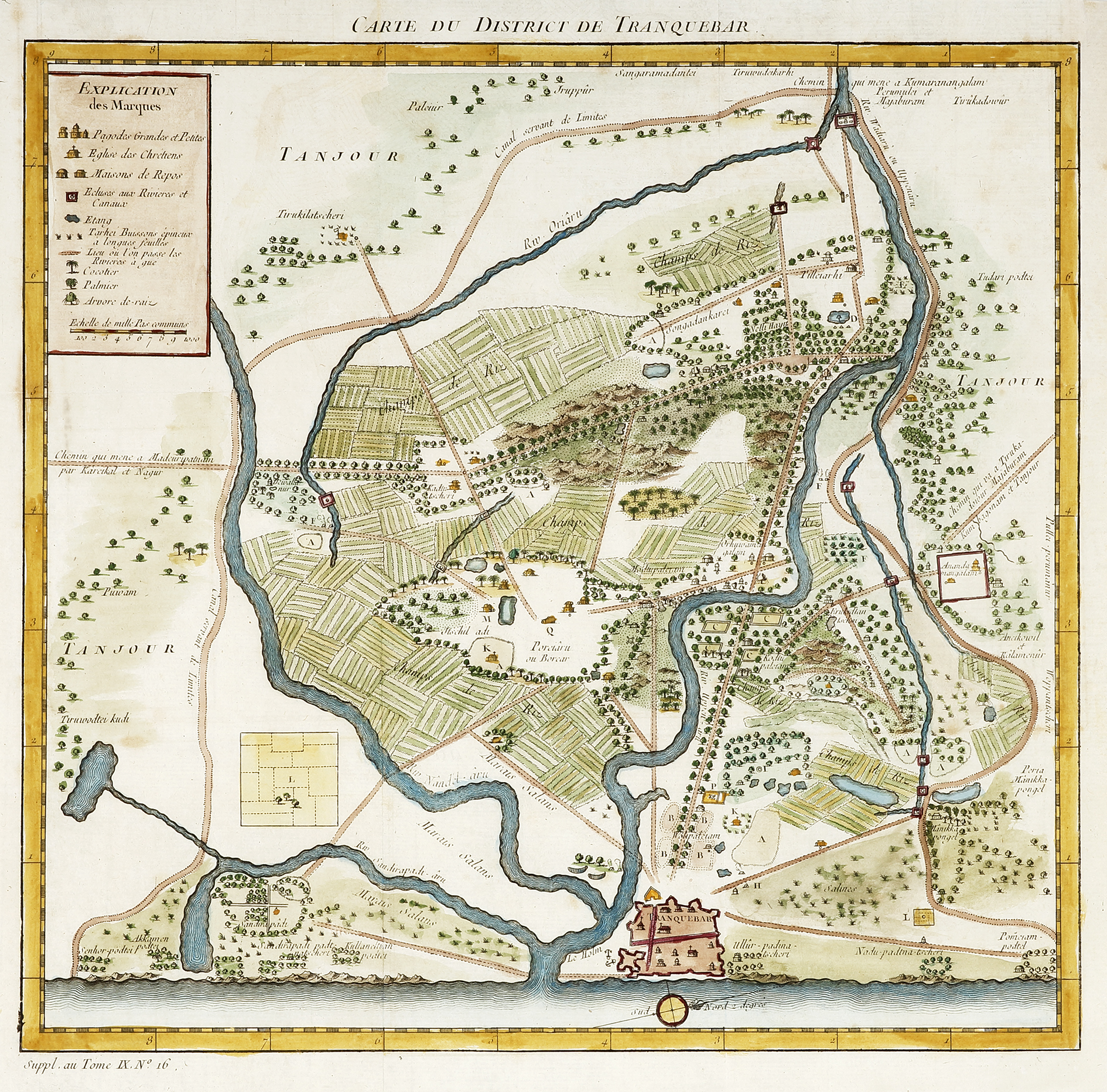
INDIA-Carte du District de Tranquebar.

INDIA-Carte du District de Tranquebar. TOWN PLANS

Superbly hand coloured example of this C.18th map of the Indian town of Tharangambadi, formerly Tranquebar, in the Mayiladuthurai district of the Indian state of Tamil Nadu on the Coromandel Coast with a key at top left of prominent sites.

It lies 15 kilometres north of Karaikal, near the mouth of a distributary named Uppanar of the Kaveri River. Tranquebar was established on 19 November 1620 as the first Danish trading post in India. King Christian IV had sent his envoy Ove Gjedde who established contact with Raghunatha Nayak of Tanjore. An annual tribute was paid by the Danes to the Rajah of Tanjore until the colony of Tranquebar was sold to the British East India Company in 1845.

From Prevost, Histoire General Du Voyages. Paris.

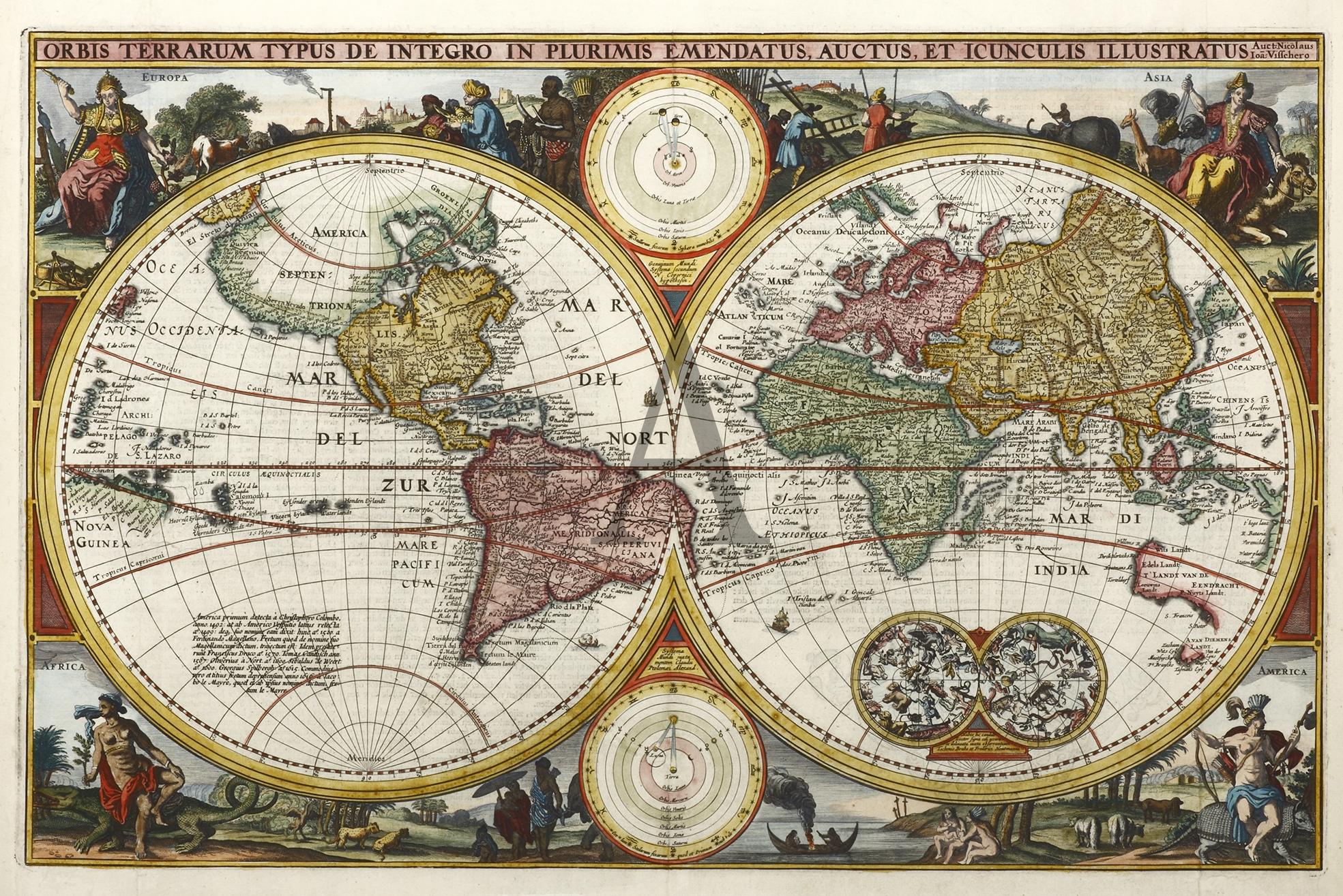
Orbis Terrarum Typus De Integro In Plurimis Emendatus, Auctus, Et Icunculis Illustratus;

Orbis Terrarum Typus De Integro In Plurimis Emendatus, Auctus, Et Icunculis Illustratus; WORLD MAPS

This was the first map to be inserted in a Dutch bible by Nicholas Visscher and became the protoype for others and was one of the earliest world maps to show the discoveries made by Abel Tasman’s on his first voyage. In the corners, the four continents are shown in allegorical form with examples of their animal life and inhabitants. Two celestial spheres and two spherical maps are also added.

Australia is shown with the discoveries made by Tasman on his first voyage 1642-3 only. Earlier Dutch discoveries are noted and these include: Hartog 1616, Houtman 1619, van Leeuwin 1622, Cartensz 1623, Nuyts 1627 and de Wit 1628. The earliest Dutch discovery of the Australian coast by Willem Jansz in 1606 on Cape York Peninsula is not shown. The VOC, in having sent Tasman, not only to chart the South Land but importantly to make contact with the natives and to ‘engage in trade’, were disappointed with the lack of trading opportunities present in the barren and inhospitable land. Consequently, the VOC lost interest in further charting of the Australian continent other than the updating of existing charts. The post-Tasman shape of Australia depicted on maps was to remain unchanged until James Cook discovered and charted the east coast in 1770.

References: Poortman 130. ill.p.196, Shirley 431, pl 318.


[H.M.S. Resolution arrives at Ship Cove, Queen Charlotte Sound, 17 May, 1773.]

[H.M.S. Resolution arrives at Ship Cove, Queen Charlotte Sound, 17 May, 1773.] Australian Printmakers

Fine untitled signed etching by Geoffrey Ingleton of Cook’s ships HMS Resolution and HMS Adventure at anchor at Charlotte Sound, New Zealand during Cook’s second voyage of exploration.

Cook had arranged a rendezvous point at Queen Charlotte Sound, New Zealand should the ships be separated on the outward bound voyage. On 8 February 1773 the ships lost contact with each other in a heavy fog.  On 18 May 1773 the Resolution arrived at Ship Cove, Queen Charlotte Sound, where the Adventure had been for several weeks.

Carte Reduite de L’Ocean Oriental ou Mers des Indes Contenant Les Costes d’Afrique, depuis le Cap den Bonne Espce….

Carte Reduite de L’Ocean Oriental ou Mers des Indes Contenant Les Costes d’Afrique, depuis le Cap den Bonne Espce…. China

The scarce first issue of this important large scale detailed sea chart, dedicated to Comte de Maurepas, French ministre de la marine to Louis XV by Nicholas Bellin, hydrographer to the French Navy.

The chart extends from Africa to Australia and north to the Tropic of Cancer. It contains the latest cartographic information of the Indian Ocean and features extensive rhumb lines.

The first French contact with the Australian coast at Eendracht Land in 1687 by Duquesne-Guitton, in command of the ship Loiseau, is noted. The English naming of Shark Bay by Dampier 1699 and the Dutch visit to Swan River by Vlamingh 1697, are added. Bellin also records the first English sighting of the Australian coast and the first recorded European shipwreck off the coast of Western Australia by the Tryall, an East India Company ship under the command of John Brookes in 1622, that had run aground on the Tryal Rocks (105km off the north-west coast of WA). Brookes’s subsequent untruthful report to the authorities in Batavia, had him place the rocks further west than their true position and in the direct course of VOC ships sailing due north for the Sunda Straits. This new information immediately prompted Gerritz, the VOC mapmaker in Batavia, to add the rocks on Dutch charts where they remained in this incorrect position for a period of almost two hundred years.

During this period the French navy, under the command of Comte de Maurepas, regained its lost prestige and France was once again recognised as a maritime power. From the French foothold of Reunion (previously Ile Bourbon) and Mauritius, the Indian Ocean increasingly became an area where the French endeavoured to expand their influence. As part of this expansion, they required their Hydrographic Office to provide up-to-date sea charts such as this.

From: Atlas de gʹeographie ancienne et moderne.

Reference: Tooley 155, p.24 (2nd ed.)

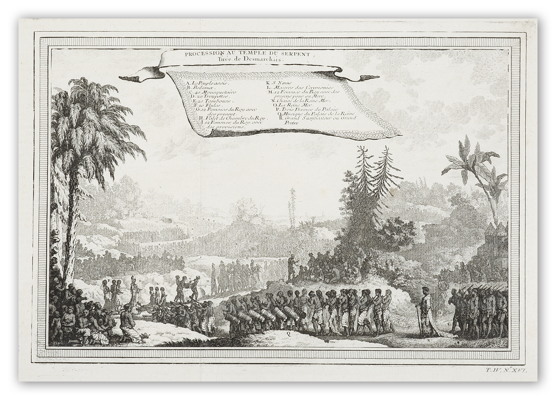
Procession au Temple du Serpent, Tiree de Desmarchais

Procession au Temple du Serpent, Tiree de Desmarchais AFRICA

C18th engraving of procession to the Snake Temple in the Kingdom of Whydah (present day Benin).

In Africa the chief centre of serpent worship was Dahomey, but the cult of the python seems to have been of exotic origin, dating back to the first quarter of the 17th century. By the conquest of Whydah the Dahomeyans were brought in contact with a people of serpent worshippers, and ended by adopting from them the beliefs which they at first despised. At Whydah, the chief centre, there is a serpent temple, tenanted by some fifty snakes. 

From Prevost, Histoire generale des voyages.

Crowning of the King of Whydah, april 1723,

Crowning of the King of Whydah, april 1723, AFRICA

C18th engraving of Crowning of the King of Whydah, April 1723 (present day Benin). 

In the centre of the engraving is a serpent indicating the cult of the python seems to have been of exotic origin, dating back to the first quarter of the 17th century. By the conquest of Whydah the Dahomeyans were brought in contact with a people of serpent worshippers, and ended by adopting from them the beliefs which they at first despised. At Whydah, the chief centre, there is a serpent temple, tenanted by some fifty snakes. 

From Prevost, Histoire generale des voyages.

Praos Bouguis a la Voile. (Baie Raffles)

Praos Bouguis a la Voile. (Baie Raffles) Northern Territory

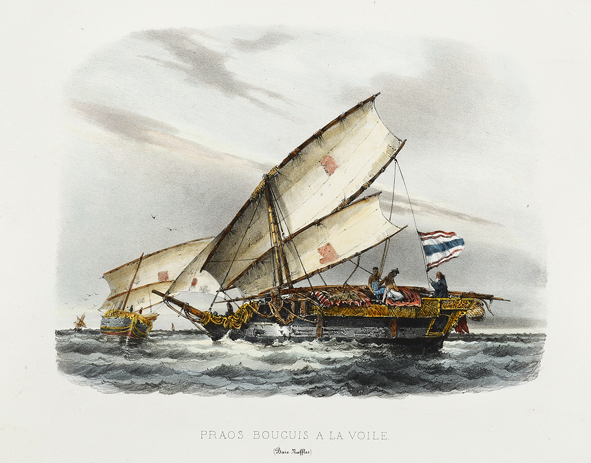
Rare lithograph of Bugis, Padewakangs, seen by Dumont D’Urville’s at Raffles Bay, Northern Territory.

Padewakangs  with tilted rectangular tanja sails, were the traditional boats used by the Bugis, Mandar, and Makassar people of South Sulawesi for long voyages. They  sailed for the coasts of northern Australia in search of trepang (sea cucumbers). The name Makassan (or Macassan) was used to for all the trepangers who came to Australia.

Raffles Bay is located at the eastern end of the Cobourg Peninsula, was the site of the second abortive attempt at settlement on the northern coastline of Australia. It was named by Phillip Parker King in 1818 after Sir Thomas Stamford Raffles, founder of Singapore. Like Flinders before him, d’Urville made contact with the Maccassar trepang (sea cucumber) fishing fleet and visited their encampment. The French arrived at the Victoria Settlement, commonly known as Port Essington, only five months after its establishment. The government intended that Port Essington be established as a major trading port like Singapore. Unfortunately, this attempt also failed and the settlement was finally abandoned in 1849.

From D’Urville, Voyage au Pole Sud et dans L’Oceanie.

[Werelt Caert]

[Werelt Caert] WORLD MAPS

Superb double-hemisphere world map decorated with the four continents shown in allegorical form, with examples of their animal life and inhabitants.

Two circular diagrams depicting the Ptolemaic and Copernican theories of the solar system are depicted at top and bottom between the hemispheres.

Australia is shown with the discoveries made by Tasman on his first voyage 1642-3 and second voyage 1644. Earlier Dutch discoveries are noted and these include: Hartog 1616, Houtman 1619, van Leeuwin 1622, Cartensz 1623, Nuyts 1627 and de Wit 1628. The earliest Dutch discovery of the Australian coast by Willem Jansz in 1606 on Cape York Peninsula is not shown. The VOC, in having sent Tasman on two voyages, not only to chart the South Land but importantly to make contact with the natives and to ‘ in trade’, were disappointed with the lack of trading opportunities present in the barren and inhospitable land. Consequently, the VOC lost interest in further charting of the Australian continent other than the updating of existing charts. The post-Tasman shape of Australia depicted on maps was to remain unchanged until James Cook discovered and charted the east coast in 1770.

References: Poortman 130. ill.p.196, Shirley 431, pl 318.

[Capt. Samuel Windridge Kyneton Troop.]

[Capt. Samuel Windridge Kyneton Troop.] Australian photographs

The only known portrait of Samuel Windridge, leader of the 1847 search for the ‘Gippsland White Woman‘.

Carte de visite portrait of Samuel Windridge (1817-1896), leader of the expedition in 1847 in search of a white woman who was thought to have been a survivor of a shipwreck and believed to have been held captive by Gippsland aborigines. The portrait shows Windridge in 1866 when he was made Captain of the Kyneton troop of the Prince of Wales Light Horse. The photographers Dufty & Carolin of Piper Street Kyneton, Victoria. Dufty was at the Pipers Street studio for only two years between 1866-1867. The carte de visite has an inscription in Indian ink in an early hand, “S. Windridge. / Captn. / Kyneton Troop.Note as well; ‘Copies of this Portrait may be had at 1s. each

Samuel Windridge was born in Warwickshire in 1817, and came to Australia on the convict transport HMS Susan which sailed from the Port of London on the 23rd September 1835. She carried 394 male convicts and a guard of officers and 30 rank and file of the 28th (North Gloucestershire) regiment, arriving in Sydney on 8th February 1836. He served in various places: Sydney, Moreton Bay (Brisbane) and Port Phillip (Melbourne) and was discharged from the Regiment in 1842 with the rank of Sergeant. After his marriage, he settled in Victoria and by 1852 he was often in charge of the gold escort from Bendigo. In 1854 he retired from the Gold Commission and settled in Kyneton. In 1860 the Kyneton Mounted Rifle Corps was formed with Samuel Windridge as one of its earliest members. In 1862 the whole of the Victorian Horse was amalgamated into one Regiment: The Prince of Wales Light Horse. Samuel Windridge rose to the rank of Lieutenant Colonel in the Kyneton Troop of the regiment. He died in 1896, aged 79 years,

Collections:
Not in any Australian institutional collection

Chronology of events for the search of the ‘White woman‘ and Samuel Windrige 

From the 1840’s rumours had circulated of a ship-wrecked white woman who was being kept captive by Gippsland aborigines. She was thought to have been from the brig Britannia (204 tons) that had been wrecked wrecked after she departed from Melbourne on 4 November 1839 for Sydney. The woman was thought to be Miss Anne MacPherson. In April 1840 a search party had found the long boat from the Britannia on Ninety Mile Beach and footprints in the sand nearby. 

Miss Anne Macpherson sometimes referred to as Ellen MacPherson (her name had been found carved on a tree) appears in the census at Port Phillip on 12 September 1838. She had been in the employ of a Mr. John McDonald of the Scottish Chiefs in Melbourne. Her brother, a Treasury official in Sydney, later offered a reward for information about her. 

November 1840:
The first report of a sighting in Gippsland, seems to have been on 15 November 1840 by Angus McMillan. While on an exploring expedition, and when approaching the coast with the intention of following the Long 
Beach (Ninety Mile) to Corner Inlet, he came across a camp of about twenty-five natives, mainly women, who ran away as McMillan’s party of four approached. They left behind many articles of European origin, including clothing, bottles, tools, musket and printed matter dated as late as June 1838. There were also three kangaroo skin bags, one of which contained the body an infant boy. The body was able to be examined by Dr. Alexander Arbuckle who believed it to be of European parentage. As they had approached the camp, they noticed that one of the fleeing women had acted differently to the others. She had been constantly looking behind while being driven onward at spear-point by the men of the group. The natives returned the following day in larger numbers, compelling McMillan’s party to leave the area. Angus McMillan reported these events to his employer, Lachlan McAllister, and were later published in the Sydney Herald on 28 December 1840. 

January 1843:
Another sighting was made in January 1843 by a party consisting of David Fermaner, John Reeve, Henry Loughnan, Mr. Sheridan and Captain Orr. They were exploring the Gippsland lakes and were at the time sailing on the south side of Lake King when they came across a group of about 200 natives. Among the natives was a white woman who was trying to escape and make her way to their boat. However she was captured and taken out of sight of the boat. 

April 1846:
Gippsland Commissioner of Crown Lands Charles Tyers instructed W H Walsh, one of the Native Police officers, to take the second division of the Native Police to Gippsland to form a search party that would be guided by Tackawadden. The young boy was initially too frightened to take part, apparently believing that Mr Walsh would shoot him. Tackawadden was the son of Bungaleena, who was believed to be holding the woman captive. Judging by the reports written by officers taking part in the search, it appears that this basic fact was not generally known. It was Sergeant Windridge, an officer of the Border Police and formerly of the Native Police, who eventually persuaded Tackawadden to assist. The aim of the search was to find and communicate with Bungaleena and the Lake Wellington group. A combined party of Border and Native Police then set off in a couple of boats on Lake Victoria in search of Tackawadden’s clan. 

1846:
Local interest was such that at least three expeditions were planned to travel to Gippsland in search of her. On one of these, handkerchiefs were distributed in the bush with the following message in English and Gaelic: WHITE WOMAN! – – – There are fourteen armed men, partly White and partly Black, in search of you. Be cautious and rush to them when you see them near you. Be particularly on the look out every dawn of morning for it is then that the party are in hopes of rescuing you. The white settlement is towards the setting sun. Another message read: “White woman – A strong armed party, headed by the Government, is now in search of you, determined to rescue you. Two Warrigals named Boondowal and Karrowutbeet, are with the white party. Be careful as far as your own safety is concerned, and do everything to throw yourself into the hands of this party. Inform the person who detains you, as well as his tribe, that he and they will be handsomely rewarded if they give you up peaceably but if they persist in detaining you that they will be severely punished. Melbourne, 4th March, 1847.” 

January 1847:
During one of the searches conducted in January 1847, Sergeant Windridge followed a group of Kurnai people who were supposedly in contact with Bungaleena, the headman suspected of holding the white woman captive. While with this group, a messenger told Windridge that Bungaleena would never give her up. The next day the group moved on but Windridge continued tracking them. Shortly after arriving at their camp, a young Aboriginal woman was brought to one of the Aboriginal men taking part in the search. Windridge thought that the Kurnai people were making a compromise offer, a fair exchange in place of the white woman. On the other hand, the offer may have equally suggested some kind of misunderstanding about what the Kurnai people of Gippsland understood to be the purpose of the search party. 

1847:
Sydney Chronicle Wednesday 28 July 1847 dispatches published from Commissioner Tyers and Samuel Windrige relating to the search for the white woman. ‘I lost no time in sending a party, consisting of five white men and five blacks, with him, under Sergeant Windridge…’ 

1864 The Government Gazette of Thursday 8 December 1864: Published promotion of Windridge. ‘Volunteer force.-Victorian Volunteer Light Horse-Samuel Windridge, Esq, to be lieutenant in the Kyneton Troop.’ 

1866:  The Argus Monday 14 May 1866 Published promotion of Windridge. ‘Cavalry – Lieu- tenant Samuel Windridge to be captain in the volunteer force, and to be officer commanding the Kyneton troop of the Prince of Wales V. V. Light Horse’ 1939 

The Argus Saturday 29 July 1939: An account of Windrige The Castlemaine Pioneers and Old Residents’ Association has sent me some notes of the career of Samuel Windridge, who came out to Sydney in 1836 as a soldier in the 28th Regiment, and later transferred to the police, serving in the Port Phillip District and retiring with the rank of inspector in 1854. Mr. Windridge lived for many years in Kyneton after he had left the public service, becoming chairman of the District and Board and a lieut.-colonel in the volunteer forces. In 1891 he came to Melbourne, and died here in 1895. His chief claim to a place in the history of this State is the fact that in 1847 he led an expedition to Gippsland to search for a white woman said to be held in captive by the aborigines.  

The efforts of this first party were fruitless, and it returned to Melbourne in January, 1847. Shortly afterwards Superintendent La Trobe sent a second body of men, under the charge of Sergeant Windridge, who was instructed to take his orders from Mr. Tyers, the Crown Lands Commissioner for Gippsland. This time the mast-head of a ship, representing a snake, was secured from the blacks. No solution of the mystery was ever found. ‘I lost no time in sending a party, consisting of five white men and five blacks, with him ( Bungelene), under Sergeant Windridge. They left head quarters on the 19th ultimo, and after a very fatiguing journey among the mountains between Mounts Buller and Gisborne (or Wellington), returned on the 4th instant, without having met with, any blacks, or seeing tracks or other indications of the object of their search. Indeed, from Sergeant Windridge’s report to me (enclosed), and from the Journals of three of the party,- CHAS. J. TYERS,Commissioner Grown Lands (Sydney Chronicle Wednesday 28 July 1847)’
Orbis Terrarum Tabula Recens Emendata et in Lucen Edita.

Orbis Terrarum Tabula Recens Emendata et in Lucen Edita. WORLD MAPS

Superb c.17th double-hemisphere world map issued in a Dutch bible, decorated with the four continents shown in allegorical form, with examples of their animal life and inhabitants engraved by Daniel Stoopendaal.

Two circular diagrams depicting the Ptolemaic and Copernican theories of the solar system are depicted at top and bottom between the hemispheres. This map was based on the second world map prepared by Nicolaas Visscher for insertion in a Dutch bible published by Pieter en Jacob Keur.

Australia is shown with the discoveries made by Tasman on his first voyage 1642-3 and second voyage 1644. Earlier Dutch discoveries are noted and these include: Hartog 1616, Houtman 1619, van Leeuwin 1622, Cartensz 1623, Nuyts 1627 and de Wit 1628. The earliest Dutch discovery of the Australian coast by Willem Jansz in 1606 on Cape York Peninsula is not shown. The VOC (Dutch East India Comapny) , in having sent Tasman on two voyages, not only to chart the South Land but importantly to make contact with the natives and to ‘in trade’, were disappointed with the lack of trading opportunities present in the barren and inhospitable land. Consequently, the VOC lost interest in further charting of the Australian continent other than the updating of existing charts. The post-Tasman shape of Australia depicted on maps was to remain unchanged until James Cook discovered and charted the east coast in 1770.


Our Torpedo Defences.

Our Torpedo Defences. SHIPS & YACHTS

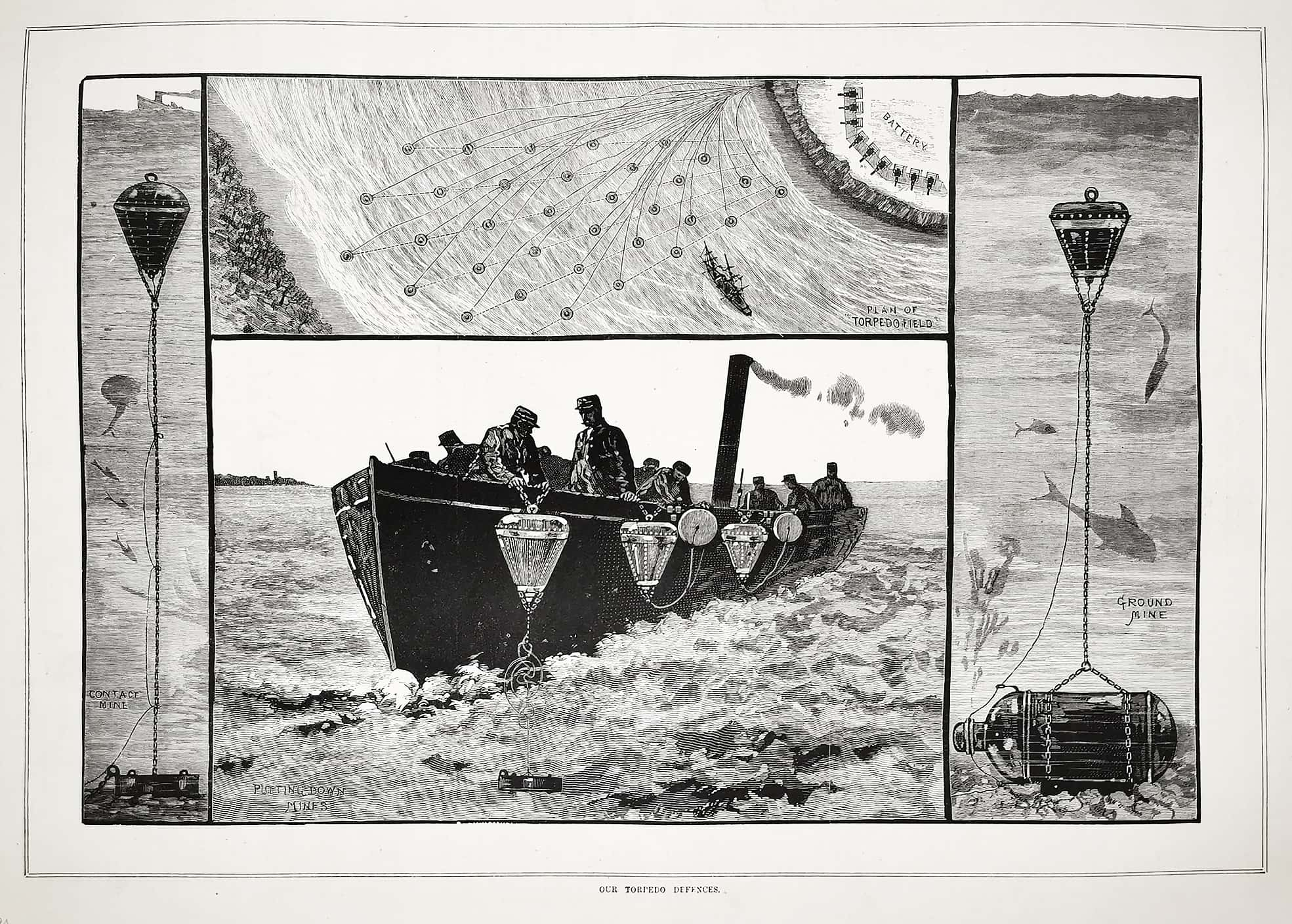
Scarce c.19th engraving showing Melbourne’s with laying of mines for colonial defences.

Inset titles:
Contact mine, Plan of torpedo field, Ground mine, Putting down mines, Torpedo boat lowering mines, Mines beneath surface of the water.

From the original edition of the Australasian Sketcher.

Werelt Caert.

Werelt Caert. WORLD MAPS

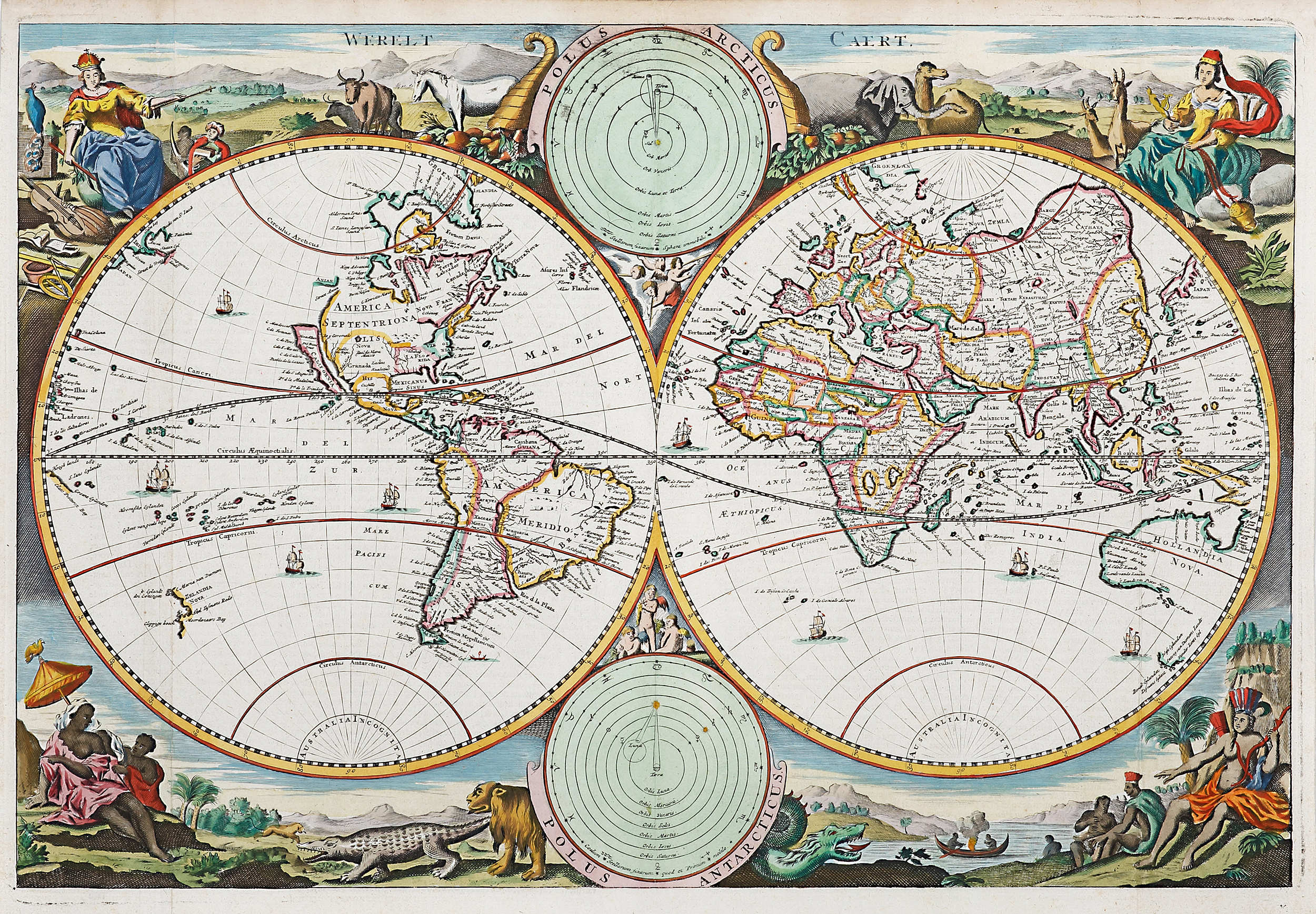
Superb c.17th double-hemisphere world map issued in a Dutch bible, decorated with the four continents shown in allegorical form, with examples of their animal life and inhabitants engraved by Daniel Stoopendaal.

Two circular diagrams depicting the Ptolemaic and Copernican theories of the solar system are depicted at top and bottom between the hemispheres. This map was based on the second world map prepared by Nicolaas Visscher for insertion in a Dutch bible published by Pieter en Jacob Keur.

Australia is shown with the discoveries made by Tasman on his first voyage 1642-3 and second voyage 1644. Earlier Dutch discoveries are noted and these include: Hartog 1616, Houtman 1619, van Leeuwin 1622, Cartensz 1623, Nuyts 1627 and de Wit 1628. The earliest Dutch discovery of the Australian coast by Willem Jansz in 1606 on Cape York Peninsula is not shown. The VOC (Dutch East India Comapny) , in having sent Tasman on two voyages, not only to chart the South Land but importantly to make contact with the natives and to ‘in trade’, were disappointed with the lack of trading opportunities present in the barren and inhospitable land. Consequently, the VOC lost interest in further charting of the Australian continent other than the updating of existing charts. The post-Tasman shape of Australia depicted on maps was to remain unchanged until James Cook discovered and charted the east coast in 1770.

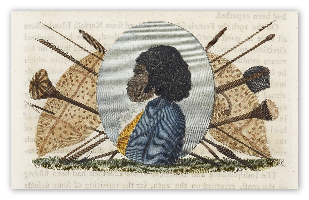
Ben-nil-long.

Ben-nil-long. Australian

Early engraved portrait of Woollarawarre Bennelong (c.1764?) a senior man of the Eora people of the Port Jackson area who belonged to the Wangal clan of the south side of Parramatta River.

Bennelong was brought to the settlement at Sydney Cove in November 1789 by order of Governor Phillip. He escaped after three months but later returned, keeping in contact with Phillip. In 1790, Bennelong asked Phillip to build him a hut on what became known as Bennelong Point, now the site of the Sydney Opera House.

Ben-nil-long.

Ben-nil-long. ABORIGINES
Early engraved portrait of Woollarawarre Bennelong (c.1764?) a senior man of the Eora people of the Port Jackson area who belonged to the Wangal clan of the south side of Parramatta River.

Bennelong was brought to the settlement at Sydney Cove in November 1789 by order of Governor Phillip. He had  escaped after three months but later returned, keeping in contact with Phillip. In 1790, Bennelong asked Phillip to build him a hut on what became known as Bennelong Point, now the site of the Sydney Opera House.

References:
Ferguson, J. A. Bibliography of Australia Volumes 1-8, Canberra 1976 390
Crittenden, V. A Bibliography Of The First Fleet. ACT 1982 69 & 70.
Hill, J. The Hill Collection of Pacific Voyages. San Diego 1974 335.
Wantrup, J.  Australian Rare Books Sydney 1987: 19 & 20

Collections:
National Library Australia: Bib ID 2283615
State Library New South Wales: Q79/60 v. 1
State Library Victoria: RARELTF 919.44 C69A
Yale University Art Gallery: DU160 .C65 1798

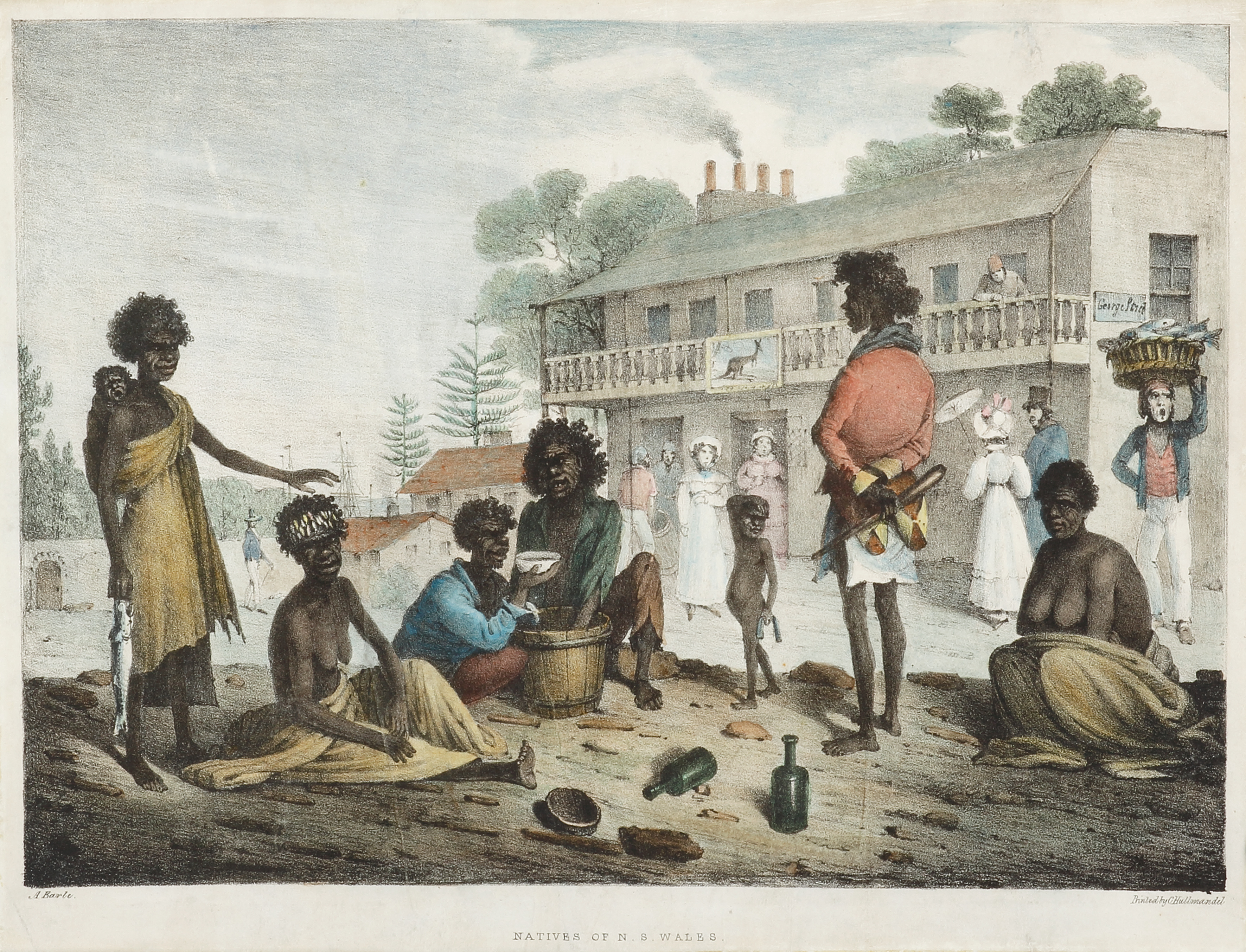
Natives of N.S. Wales, as seen in the streets of Sydney.

Natives of N.S. Wales, as seen in the streets of Sydney. NSW - Sydney

Very rare and important lithograph by Augustus Earle, the first professional artist in the colony. This is one of the most significant images produced during the early colonial years of Sydney.

From Earle’s, Views in New South Wales and Van Diemen’s Land. Australian Scrap Book London: Charles Hullmandel, 1830. Plate one from part 4.

‘The coats  of the aboriginal man with the waddy, standing with his back to the artist wears an officer’s coatee. This one is red with buff facings, the little tails turned up to reveal the buff. It originated either with the 48th Regiment – in New South Wales between 1817 and 1824 – or the 3rd Regiment, three detachments of which were in Sydney from 1823 to 1827, the same time Earle was visiting. The fact that warriors were wearing officers’ coats is significant. While soldiers were forbidden to sell or give away their uniforms, officers purchased their own, and were thus free to gift or trade them. It is possible that warriors had personal links with the officers from whom they acquired their jackets, in the same way that warriors in the early contact period had exchanged names with officers, and were known by these European names long after their namesakes had departed.’

In the following institutional collections:
National Gallery of Australia Collection: 
Bib ID513268
State Library of NSW : IE8795760

Rerences:
Butler (1982), 11
Ferguson (1941-69, 1986), 1342
Wantrup 219, p412
Australian Dictionary of Biography

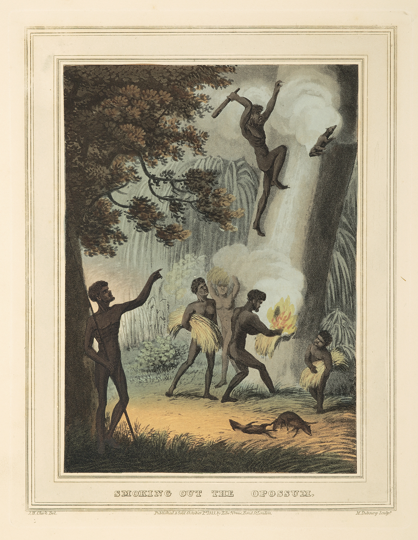
Smoking Out the Opossum.

Smoking Out the Opossum. ABORIGINES

Rare aquatint by John Lewin of New South Wales aborigines smoking out possums.

John Heaviside Clark is named as the artist at lower left, although it is known that the original sketches were made by John Lewin as Clark was just a commercial artist working in London whose only contact with Australia was through earlier prints he had engraved. His contribution to this work consisted in turning the original sketches into finished drawings. “..they are justly celebrated and are without question the most attractive and sympathetic of the early depictions of the native inhabitants.” Wantrup

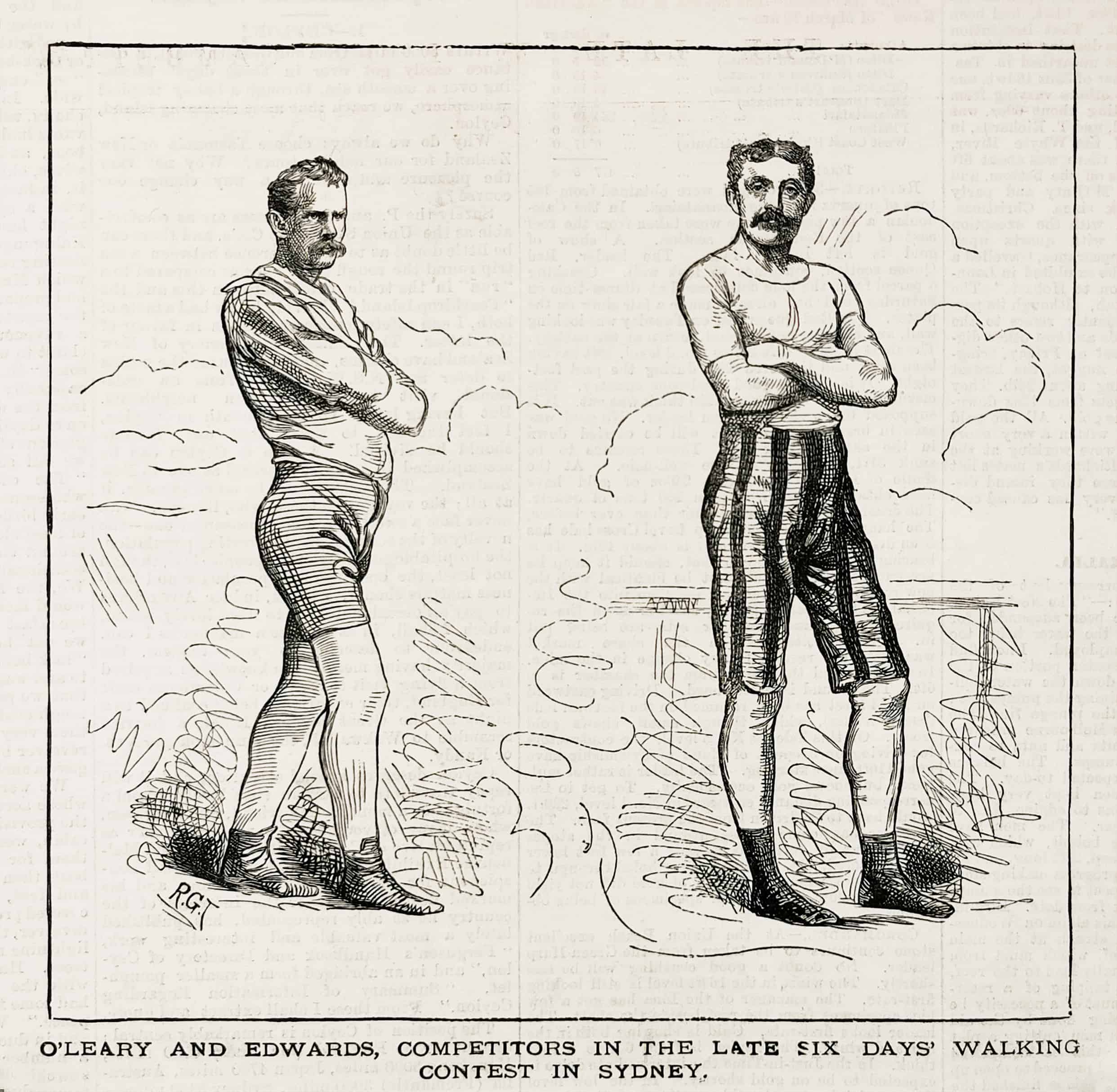
O’Leary and Edwards, Competitors in the Late six days’ Walking Contest in Sydney.

O’Leary and Edwards, Competitors in the Late six days’ Walking Contest in Sydney. SPORTS

Rare engraving of an early walking race in Australia between W. Edwards who beat Daniel O’Leary in a six day match for £400 in Sydney. Week ending Mar 19 1883 Alfred Park, Sydney. In the 6 day walk W. Edwards 373.5 miles, Daniel O’Leary USA 350.5 miles.

Racewalking had developed as one of the original track and field events of the first meeting of the English Amateur Athletics Association in 1880. In Australia the first Athletics Congresses to adopt formal rules for the sport of walking.  A. O. Barrett  and R. H. Croll  submitted these propositions to the 1900 Australasian Convention of all the amateur associations in Auckland.

1. That a racing walker must have contact with the ground with one foot during a stride, and with both feet at the end of a stride.
2. That the heel of the front foot must touch the ground before the back foot leaves it.
3. That as the heel of the front foot touches the ground the leg must not be bent, its knee must be locked.
4. That the body and head must be kept upright. 

From the original edition of the Town and Country Journal.

Pecheurs de Tripang a La Baie Raffles.

Pecheurs de Tripang a La Baie Raffles. DUMONT D'URVILLE

Rare lithograph of Dumont D’Urville at Raffles Bay which is at the eastern end of the Cobourg Peninsula. Raffles Bay was the site of the second abortive attempt at settlement on the northern coastline of Australia. It was named by Phillip Parker King in 1818 after Sir Thomas Stamford Raffles, founder of Singapore. Like Flinders before him, d’Urville made contact with the Maccassar trepang (sea cucumber) fishing fleet and visited their encampment. The French arrived at the Victoria Settlement, commonly known as Port Essington, only five months after its establishment. The government intended that Port Essington be established as a major trading port like Singapore. Unfortunately, this attempt also failed and the settlement was finally abandoned in 1849.

From D’Urville, Voyage au Pole Sud et dans L’Oceanie.

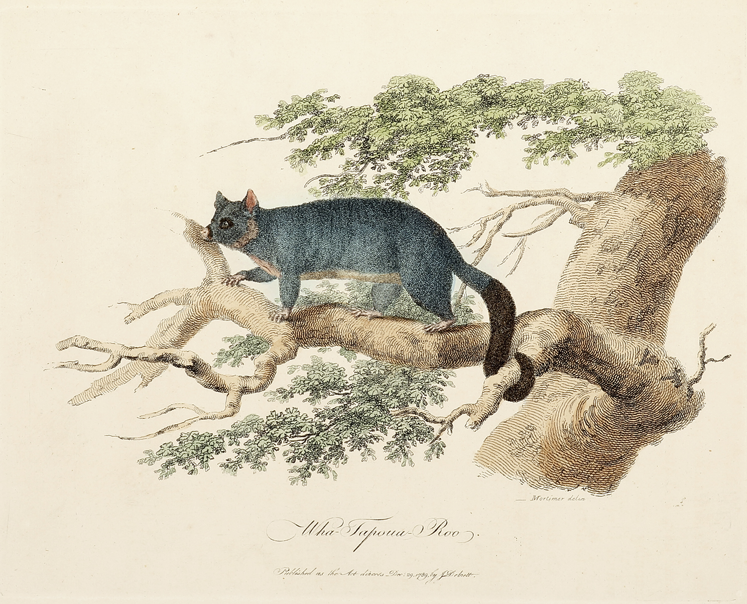
Wha-Tapoua-Roo.

Wha-Tapoua-Roo. Australian - General

Rare c.18th engraving of the Common Brushtail possum.

Common name: Common brushtail possum
Aboriginal names: Koomaal in Wudjari, Mudhay in Yuwaalayaay, Mudhay in Gamilaraay / Gamilaroi / Kamilaroi, Mudhay in Yuwaalaraay
Modern binomial name: Trichosurus vulpecula (Recent synonyms Trichosurus fuliginosus)
First described: Kerr, 1792
Distribution: Australia wide

John White’s description:
This animal is about the size of a racoon, is of a dark grey colour on the back, becoming rather lighter on the sides, which terminates in a rich brown on the belly. The hair is of two kinds, a long hair, and a kind of fur, and even the long hair, at the roots, is of the fur kind. The head is short the eyes rather prominent the ears broad, not peaked. The teeth resemble those of all the animals from that country I have hitherto seen. The incisors are not continued into the grinders by intermediate teeth, although there are two teeth in the intermediate space in the upper jaw, and one in the lower. The incisors are similar to those of the kangaroo, and six in number in the upper jaw, opposed by two in the lower, which have an oblique surface extending some distance from their edge, so as to increase the surface of contact. There are two cuspidati on each side in the upper jaw, and only one in the lower five grinders on each side of each jaw, the first rather pointed, the others appear nearly of the same size, and quadrangular in their shape, with a hollow running across their base from the outside to the inner, which is of some depth and another which crosses it, but not so deep, dividing the grinding surface into four points. On the fore foot there are five toes, the inner the shortest, resembling, in a slight degree, a thumb. The hind foot resembles a hand, or that of the monkey and opossum, the great toe having no nail, and opposing the whole sole of the foot, which is bare. The nails on the other toes, both of the fore and hind foot, resemble, in a small degree, those of the cat, being broad and covered and the last bone of the toe has a projection on the under side, at the articulation. Each nail has, in some degree, a small sheath, covering its base when drawn up. The tail is long, covered with long hair, except the under surface of that half towards the termination, of the breadth of half an inch, becoming broader near the tip or termination this surface is covered with a strong cuticle, and is adapted for laying hold.

From John White’s, Journal of a Voyage to New South Wales

References:
Ferguson, J. A. Bibliography of Australia Volumes 1-8, Canberra 1976 97.
Hill, J. The Hill Collection of Pacific Voyages. San Diego 1974 1858.
Nissen, C. Die illustrierten Vogelbucher. Stuttgart 1995 ZBI 4390.
Abbey, J.R. Travel in Aquatint and Lithography 1770-1860. London 1972 605.
Wantrup, J. Australian Rare Books. Sydney 1987 17.
Crittenden, V. A Bibliography Of The First Fleet. ACT 1982 248.
Strahan, R. A Dictionary of Australian Mammal Names. Sydney 1981 pp. 88-89.

Collections:
National Library Australia: Bib ID 87340
State Library New South Wales: Call Number: MRB/Q991/2A2
National Gallery Victoria: Accession Number2012.31
State Library Victoria: CCF 919.44 W58
National Museum of Australia: Object number 2007.0035.0001
Sydney University Library: record=b1288848~S4