-
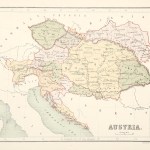
Austria, Czechoslovakia, Hungary, Poland, Ukraine (64)
-
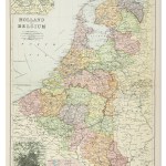
Belgium & Holland/Netherlands (80)
-
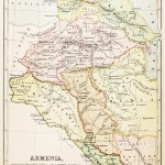
Caucasus: Armenia, Azerbaijan, Georgia (20)
-
Europe Continent (118)
-
France (204)
-
Germany (189)
-
Greece, Balkans, Cyprus, Bulgaria, Albania, Macedonia (158)
-
Italy (194)
-
Malta (7)
-
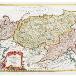
Russia (136)
-
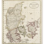
Scandinavia: Denmark, Finland, Iceland, Norway and Sweden (86)
-
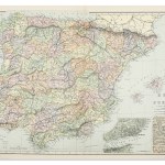
Spain & Portugal (104)
-
Switzerland (43)
Showing 577–672 of 874 results
-

1864
Turkey in Europe.
$A 55 Add to cart -

1864
Denmark Sleswig and Holstein
$A 65 Add to cart -

1864
Sweden and Norway.
$A 45 Add to cart -
 Italy")
1864
Italy (Southern Part)
$A 195 Add to cart -

1864
Europe de l’an 410 a l’an 519 de J.C.
$A 85 Add to cart -
 Italy")
1864
Italy, (Northern Part.)
$A 175 Add to cart -

1864
Europe.
$A 110 Add to cart -

1864
Switzerland
$A 65 Add to cart -

1864
Belgium
$A 75 Add to cart -

1864
France
$A 85 Add to cart -

1864
Russia in Europe & Poland.
$A 65 Add to cart -
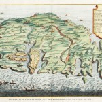
![[EUROPE-ITALY] Gulf of Naples Surveyed by M.Darondeau & Gaussin: Imp. French Navy. 1857....](https://antiqueprintmaproom.com/wp-content/uploads/2024/05/MG_9692web-270x189.jpg "[EUROPE-ITALY] Gulf of Naples Surveyed by M.Darondeau & Gaussin: Imp. French Navy. 1857…. Italy")
1867
[EUROPE-ITALY] Gulf of Naples Surveyed by M.Darondeau & Gaussin: Imp. French Navy. 1857….
$A 350 Add to cart -

1869
Russia in Europe.
$A 20 Add to cart -

1869
Holland and Belgium.
$A 40 Add to cart -

1869
Sweden & Norway.
$A 20 Add to cart -

1869
France.
$A 25 Add to cart -

1869
Turkey & Greece.
$A 40 Add to cart -

1870
Spain & Portugal.
$A 85 Add to cart -

1870
France
$A 30 Add to cart -

1871
Sud-West Deutschland und Schweiz
$A 35 Add to cart -

1871
Spanische Halbinsel
$A 85 Add to cart -

1871
Spanische Halbinsel
$A 55 Add to cart -

1871
Sud-West Deutschland und Schweiz
$A 50 Add to cart -

1872
Carte Physique et Politique de la Suisse
$A 35 Add to cart -

1872
Europe.
$A 35 Add to cart -
![[EUROPE-ITALY] Catania to Cefalu including the Strait of Messina](https://antiqueprintmaproom.com/wp-content/uploads/2024/05/MG_8903web-270x186.jpg "[EUROPE-ITALY] Catania to Cefalu including the Strait of Messina Italy")
1872
[EUROPE-ITALY] Catania to Cefalu including the Strait of Messina
$A 650 Add to cart -

1872
Asie Mineure, Syrie, Phenicie
$A 75 Add to cart -

1872
1715-1790 Europe Inde Antilles
$A 60 Add to cart -

1872
Nordost Russland
$A 20 Add to cart -

1872
Carte Physique De L’Allemagne du Nord.
$A 40 Add to cart -

1872
Carte Physique De L’Allemagne du Sud et de L’Italie du Nord Chaine des Alpes.
$A 40 Add to cart -

1872
Empire Des Arabes Et Demembrement de L’Empire de Charlemagne.
$A 90 Add to cart -

1872
Carte Physique de la France.
$A 45 Add to cart -

1872
Europe A L’Epoque Des Croisades
$A 90 Add to cart -

1872
Spanien und Portugal
$A 55 Add to cart -

1872
Carte Physique De L’Europe
$A 40 Add to cart -

1872
Europe de 1815 a 1866
$A 40 Add to cart -

1872
Niederlande und Belgien
$A 55 Add to cart -

1872
888-1095 Europe Feodale pendant Le X et Le XI Siecle
$A 35 Add to cart -

1872
Nord Westliches Deutschland, Niederlande und Belgien
$A 50 Add to cart -

1872
Europe Politique et Ethnographique
$A 65 Add to cart -

1872
Europe pour L’invasion Des Barbares
$A 65 Add to cart -

1873
Die Preussischen Provinzen Preussen Und Posen
$A 65 Add to cart -

1873
Sud-Westliches Deutschland und die Schweiz
$A 45 Add to cart -

1873
Central-Russland
$A 20 Add to cart -

1873
Sud-Schweden, Die Russischen. Ostsee-Provinzen, Polen & West-Russland.
$A 45 Add to cart -

1873
Frankreich In 4 Blattern
$A 55 Add to cart -

1873
Map of Part of the Province of Huelva, Spain; Showing, Position of the Rio Tinto Company’s Property, and the Port of Huelva. / Sketch Shewing the Proposed Workings for Developing the Rio Tinto Mines
$A 2,250 Add to cart -

1874
Frankreich In 4 Blattern
$A 45 Add to cart -

1874
Frankreich Und Die Schweiz.
$A 65 Add to cart -

1874
Islands in the Atlantic
$A 175 Add to cart -

1875
Frankreich In 4 Blattern
$A 45 Add to cart -

1875
Grece Moderne
$A 155 Add to cart -

1875
Greece
$A 75 Add to cart -

1875
Spanien Und Portugal
$A 95 Add to cart -

1875
Frankreich In 4 Blattern
$A 40 Add to cart -

1875
Spain & Portugal
$A 55 Add to cart -

1876
France Feodale
$A 60 Add to cart -

1876
Suisse ou Helvetie
$A 75 Add to cart -

1876
Empire D’Autriche
$A 125 Add to cart -

1876
Italie Septentrionale
$A 55 Add to cart -

1876
France Physique
$A 35 Add to cart -
 Germany")
1876
Empire D’Allemagne (Ancienne Confederation Germanique)
$A 65 Add to cart -

1876
Grece Modern
$A 195 Add to cart -

1876
Tirnova
$A 55 Add to cart -

1876
Das Mundungs-cebiet des Ob und Jenissei. Mit Benutzung von Nordenskiolds Messungen von A. Petermann.
$A 75 Add to cart -

1876
Das Mundungs-cebiet des Ob und Jenissei. Mit Benutzung von Nordenskiolds Messungen von A. Petermann.
$A 65 Add to cart -

1876
Russie D’Europe
$A 30 Add to cart -

1877
Russland’s Eisenbahnen & Wasserstrassen
$A 85 Add to cart -

1877
Atlas Universel Plan De Stockholm
$A 165 Add to cart -

1877
Atlas Universel Plan de Moscou
$A 375 Add to cart -
 Germany")
1877
‘Empire of Germany (Northern Portion)
$A 75 Add to cart -

1877
France
$A 85 Add to cart -

1877
Originalkarte des Isthmus zwischen dem Karischen Meere und dem ob.
$A 50 Add to cart -

1877
Atlas Universel Plan de Bruxelles d’apres les Documents Officels
$A 165 Add to cart -

1877
Empire of Germany South West Part including Alsace and a portion of Lorraine
$A 85 Add to cart -

1877
Belgium and the Netherlands
$A 60 Add to cart -

1877
Allemagne du Nord-Est
$A 20 Add to cart -
 Belgium & Holland/Netherlands")
1877
Atlas Universel Plan De Gand (Belgique)
$A 85 Add to cart -
 Austria, Czechoslovakia, Hungary, Poland, Ukraine")
1877
Atlas Universel Plan D’Odessa (Russie)
$A 110 Add to cart -

1877
Europe by Keith Johnston, F.R.S.E.
$A 65 Add to cart -

1877
Allemagne du Nord-Ouest Pays Bas et Belgique
$A 20 Add to cart -
 Germany")
1877
Atlas Universel Plan de Dublin (Irande)
$A 225 Add to cart -

1877
Greece by Keith Johnston. F.R.S.E.
$A 175 Add to cart -
 Belgium & Holland/Netherlands")
1877
Atlas Universel Plan De Liege (Belgique)
$A 75 Add to cart -

1877
Plan de Vienne Atlas Universel
$A 375 Add to cart -

1877
Allemagne Pays-Bas, Belgique et la Suisse
$A 35 Add to cart -
 Italy")
1877
Atlas Universel Plan de Trieste (Italie)
$A 125 Add to cart -

1877
Plan de Cologne de L’Atlas Universel
$A 125 Add to cart -
 Belgium & Holland/Netherlands")
1877
Atlas Universel Plan De Luxembourg (Duche du Luxembourg)
$A 75 Add to cart -

1877
Atlas Universel Plan de Milan
$A 145 Add to cart -

1877
European Russia by Keith Johnston, F.R.S.E.
$A 55 Add to cart -

1877
Spain & Portugal
$A 55 Add to cart -

1877
Deutsche & Romanen in sud-Tirol Venetien Nach Chr. Schueller
$A 65 Add to cart -
 Germany")
1877
Atlas Universel Plan de Munich (Baviere)
$A 195 Add to cart -

1877
Atlas Universel Amsterdam
$A 125 Add to cart
Showing 577–672 of 874 results