The Blaeu Mapmaking Family
The Blaeu Mapmaking Family
Few names in the history of cartography carry as much prestige as the Blaeu family of Amsterdam. Active during the Dutch Golden Age, the Blaeus elevated mapmaking to a union of science, art, and commerce. Their atlases and wall maps not only guided merchants and explorers but also adorned the homes of wealthy patrons, symbolising knowledge and worldliness.
Origins with Willem Janszoon Blaeu (1571–1638)
The dynasty began with Willem Janszoon Blaeu, a student of the great Danish astronomer Tycho Brahe. Trained in astronomy and instrument making, Willem combined technical precision with a craftsman’s skill. Establishing his workshop in Amsterdam around 1596, he produced globes, instruments, and some of the earliest printed sea charts. His work reflected both navigational practicality and aesthetic refinement, with elaborate decorative cartouches, coats of arms, and allegorical figures enhancing geographic information. In 1633, Willem was appointed the official cartographer of the Dutch East India Company (VOC), giving his firm privileged access to the latest geographical discoveries from around the globe.
Joan and Cornelis Blaeu
After Willem’s death in 1638, his sons Joan (1596–1673) and Cornelis (1610–1648) inherited the business. Cornelis worked closely with Joan but died relatively young, leaving Joan to carry forward the family’s legacy. Under his direction, the Blaeu press expanded dramatically, producing wall maps, city plans, and above all, atlases of unprecedented scope.
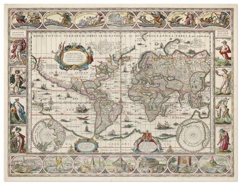
The Atlas Major
The pinnacle of the Blaeu family’s achievements was the Atlas Major, first published in Latin between 1662 and 1672. This monumental work, comprising up to twelve volumes and nearly 600 maps, was the most ambitious atlas of the 17th century. It covered not only the continents and seas but also included detailed maps of individual regions, cities, and provinces. The Atlas Major was as much a work of art as of geography: the maps were engraved with extraordinary finesse, richly hand-coloured, and adorned with vignettes of ships, mythological figures, and local scenes. Copies were prized by princes, scholars, and collectors across Europe, symbolising the reach of Dutch commerce and learning.
Scientific and Artistic Significance
The Blaeus embodied the Dutch cartographic tradition’s balance between accuracy and ornament. Their maps drew upon the latest reports from VOC voyages, astronomers, and surveyors, ensuring geographic credibility. At the same time, the elegance of their design made their maps objects of display as much as instruments of navigation. The family’s work exemplified the broader cultural moment of the Dutch Golden Age, when science, art, and trade were closely intertwined.
Decline and Legacy
The Blaeu enterprise came to an abrupt end in 1672, when a devastating fire destroyed the family’s printing house and much of their stock. Joan Blaeu, already weakened by age and illness, died the following year. Despite this tragic conclusion, the Blaeus’ influence endured. Their atlases and wall maps remained in use long after, and their visual style shaped European mapmaking well into the 18th century.
Today, the name Blaeu evokes both scientific achievement and artistic splendour. Their maps are celebrated not only for the geographic knowledge they convey but also for their enduring beauty, making them among the most sought-after treasures of early modern cartography.