Showing 49–69 of 69 results
-

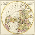
1895
South Polar Regions
$A 125 Add to cart -

1897
Icebergs in the Southern Ocean No. 2 1895 6 & 7
$A 325 Add to cart -

1898
Karte Der Sudpolarforschungen.
$A 110 Add to cart -

1904
Sud-Polarlander.
$A 145 Add to cart -

1904
Planigloben Der Erde.I.
$A 85 Add to cart -

1913
Planigloben der Erde.II.
$A 90 Add to cart -
 Map of Erebus Bay-Ross Island. Antarctica, Southern Waters")
1923
British Antarctic Expedition, 1910 (Terra Nova) Map of Erebus Bay-Ross Island.
$A 225 Add to cart -
 Map of Granit Harbour. Antarctica, Southern Waters")
1923
British Antarctic Expedition, 1910 (Terra Nova) Map of Granit Harbour.
$A 375 Add to cart -
 Map of Robertson Bay & Cape Adare. Antarctica, Southern Waters")
1923
British Antarctic Expedition, 1910 (Terra Nova) Map of Robertson Bay & Cape Adare.
$A 525 Add to cart -

1923
The Great Ice Barrier & King Edward Land. Cape Crozier to Cape Colbeck.
$A 650 Add to cart -
 Map of Terra Nova Bay Antarctica, Southern Waters")
1923
British Antarctic Expedition, 1910 (Terra Nova) Map of Terra Nova Bay
$A 325 Add to cart -
 Map to Illustrated Pole Journey. / Map of Beardmore Glacier. Antarctica, Southern Waters")
1923
British Antarctic Expedition, 1910 (Terra Nova) Map to Illustrated Pole Journey. / Map of Beardmore Glacier.
$A 650 Add to cart -

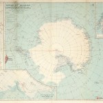
1923
Map of South Polar Regions
$A 850 Add to cart -
 Map of the Ross Sea Sector of the Antarctic. Antarctica, Southern Waters")
1923
British Antarctic Expedition, 1910 (Terra Nova) Map of the Ross Sea Sector of the Antarctic.
$A 850 Add to cart -
 Map of Mc.Murdo Sound Region. Ross Sea. Antarctica, Southern Waters")
1923
British Antarctic Expedition, 1910 (Terra Nova) Map of Mc.Murdo Sound Region. Ross Sea.
$A 550 Add to cart -
 Map of the Ferrar-Koettlitz District Mc. Murdo Sound Antarctica, Southern Waters")
1923
British Antarctic Expedition, 1910 (Terra Nova) Map of the Ferrar-Koettlitz District Mc. Murdo Sound
$A 525 Add to cart -
 Map of Cape Evans (Winter Quarters.) Antarctica, Southern Waters")
1923
British Antarctic Expedition, 1910 (Terra Nova) Map of Cape Evans (Winter Quarters.)
$A 325 Add to cart -
 Map of Granite Harbour. POLAR")
1923
British Antarctic Expedition, 1910 (Terra Nova) Map of Granite Harbour.
$A 550 Add to cart -
 Map of the Cape Royds District, Ross Island. Antarctica, Southern Waters")
1923
British Antarctic Expedition, 1910 (Terra Nova) Map of the Cape Royds District, Ross Island.
$A 225 Add to cart -
 Hut Point Peninsula Ross Island Antarctica, Southern Waters")
1923
British Antarctic Expedition, 1910 (Terra Nova) Hut Point Peninsula Ross Island
$A 225 Add to cart -

1948
Falkland Islands and Dependencies
$A 195 Add to cart
Showing 49–69 of 69 results