The Charting of Australia from the 1600s
The charting of Australia was a gradual process, unfolding over three centuries through the work of explorers, navigators, and surveyors from multiple nations. By the early 20th century, the continent’s outline, coastal hazards, and inland geography were well recorded — a far cry from the speculative forms that first appeared on European maps.
Seventeenth Century: Dutch Beginnings
The first significant European mapping of Australia came with the Dutch East India Company (VOC) in the early 1600s. In 1616, Dirk Hartog made landfall on the west coast, leaving a pewter plate as a record. Over subsequent decades, VOC captains including Jan Carstensz, Pieter Nuyts, and Gerrit Frederikszoon de Witt charted stretches of the north, west, and south coasts. Abel Tasman’s voyages of 1642 and 1644 were the most ambitious, producing maps that connected these fragments into the outline of “New Holland.” Though incomplete, these charts established the framework for future exploration.
Eighteenth Century: British and French Interest
By the 1700s, “New Holland” appeared widely in European atlases, largely from Dutch sources. The English navigator William Dampier, visiting in 1688 and 1699, added detail to parts of the west and north coasts, his reports stimulating British curiosity. In the late 18th century, scientific exploration expanded. James Cook’s first voyage (1768–1771) charted the entire east coast with remarkable precision, naming it New South Wales and claiming it for Britain. Meanwhile, French expeditions under La Pérouse and later Bruni d’Entrecasteaux contributed valuable observations, reflecting the Enlightenment spirit of shared geographic knowledge.
Early Nineteenth Century: Completing the Coastline
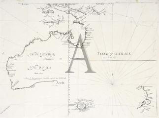
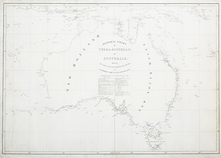
With the establishment of a British penal colony in 1788, accurate coastal charts became a necessity. Matthew Flinders and George Bass’s circumnavigation of Tasmania in 1798 proved it to be an island. From 1801 to 1803, Flinders undertook the first circumnavigation of the continent, producing his General Chart of Terra Australis (1814), the first map to show a nearly complete outline. At the same time, French navigator Nicolas Baudin’s expedition, with cartographer Louis de Freycinet, mapped much of the southern coast in detail, in part overlapping Flinders’ work.
Mid to Late Nineteenth Century: Hydrography and Inland Surveys
From the 1820s to the 1860s, the Royal Navy’s Hydrographic Office, aided by colonial survey departments, refined coastal charts, identifying reefs, shoals, and harbour depths critical for navigation. Phillip Parker King’s surveys filled many remaining gaps, particularly in northern waters. Inland exploration by Sturt, Mitchell, Leichhardt, and Eyre mapped river systems, mountain ranges, and desert regions, gradually integrating inland geography into broader colonial maps.
By mid-century, lithographic printing enabled faster, more economical production of maps, allowing updated charts to circulate widely among mariners, settlers, and government offices. Cadastral surveys expanded, mapping agricultural lands, mining districts, and new towns.