
Showing 1–48 of 287 results
-

1572
Cairus Quae Olim Babylon Aegypt Maxima Urbs
$A 1,250 Add to cart -

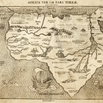
1575
Africae Tabula Nova.
$A 2,850 Add to cart -

1588
Cyria / Cypern / Palestina / Mesopotamia / Babylonia / Chaldea und zwey Arabia mit Bergen Wassern und Stetten.
$A 850 Add to cart -

1631
Africae Nova Tabula
$A 2,350 Add to cart -

1662
Lumen Historiarum per Occidentem ex conatibus Fran. Haraei Antuerpiae.
$A 650 Add to cart -

1681
Nigritia.
$A 95 Add to cart -
![Insulae Canariae. [Canary Islands]](https://antiqueprintmaproom.com/wp-content/uploads/2020/06/mg_2158_copy_1-270x222.jpg "Insulae Canariae. [Canary Islands] Africa Countries")
1681
Insulae Canariae. [Canary Islands]
$A 145 Add to cart -

1696
Asia Divisa nelle sue Parti secondo lo stato presente Descritta, e Dedicata…
$A 6,500 Add to cart -

1713
L’Afrique Selon les Nouvelles Observationes Academiae Regiae Scientiarum et Exquisitissimas…..
$A 1,650 Add to cart -
![EAST INDIES ROUTE-[Baya de Saldanha / Cabo De Boa Esperanca]](https://antiqueprintmaproom.com/wp-content/uploads/2021/07/MG_3714-copy-270x214.jpg "EAST INDIES ROUTE-[Baya de Saldanha / Cabo De Boa Esperanca] AFRICA")
1726
EAST INDIES ROUTE-[Baya de Saldanha / Cabo De Boa Esperanca]
$A 575 Add to cart -

1729
The South Part of Africa. and the Island Madagascar. Here the Portugueze have many Settlements, and all the Trade. By H. Moll Geographer 1729. sic
$A 265 Add to cart -

1730
Africae Juxta Navigationes et observationes Recentissimas Aucta, Correcta et in sua Regna et Status Divisia in Lucem Edita…
$A 1,450 Add to cart -

1730
Aegyptus Hodierna Ex Itinerario Celeberrimi viri Pauli Lucae….
$A 675 Add to cart -

1732
Africa ex Bello Africano C.Julii Caesaris
$A 55 Add to cart -

1732
Lybia according to Herodotus
$A 55 Add to cart -

1740
Carta Nuova dell’ Arabia
$A 850 Add to cart -

1740
Stati Del Turco situati Nell’Europa Asia ed Affrica
$A 550 Add to cart -
")
1744
Carte pour Servir a l’Histoire Philosophique et Politique des Etablissemens et du Commerce des Europeens dans lex deux Indes
$A 375 Add to cart -

1745
SPAIN-A Map of Spain
$A 110 Add to cart -

1746
Cours De La Riviere De Sanaga ou Senegal. Suite Du Cours De La Riviere De Senegal Depuis I’Ifle de Bilbas.
$A 125 Add to cart -

1746
Cours De La Riviere De Senegal Depuis le Defert Jufqu’a L’Ifle de Morfil Avec le Lac Du Panier Foule.
$A 85 Add to cart -

1746
Carte de la Coste Occidentale D’Afrique Depuis le Cap Blanc Jusqu’a Tanit.
$A 95 Add to cart -

1746
Isle De May, Veue De L’Isle S.Jago ou St Jacques, Le Havre De Praya.
$A 90 Add to cart -

1746
Plan De La Baye De L’Isle De St Vincent, Une des Ifles du Cap Verd.
$A 110 Add to cart -

1746
Plan du Fort de Mozambique lire de Faria.
$A 110 Add to cart -

1746
Carte De L’Entree De La Riviere De Sanaga ou Senegal
$A 90 Add to cart -

1746
Carte Exacte de la Cote du Cap Verd
$A 110 Add to cart -

1746
Coste Occidentale D Afrique Depuis le XI Degre’ de Latitude Meridionale Jusqu’au Cap de Bonne Esperance…
$A 125 Add to cart -

1747
Plan De la Baye et Isle D’Arguim Leve par un Pilote Francoise Echelle Lieues Communes de France.
$A 65 Add to cart -

1747
A Map of Africa Propria and Numidia.
$A 125 Add to cart -

1747
Plan Du Fort St Louis Dans L’Isle De Sanaga Ou Du Senegal.
$A 110 Add to cart -

1747
Africa Proper.
$A 125 Add to cart -

1748
AFRICA-Plan de L’Isle De Goree Avec ses Fortifications
$A 165 Add to cart -

1748
Vue de la Rade de L’Ile De Goree
$A 65 Add to cart -

1748
Plan de L’Isle De Goree, sur les desseins du Sr. Compagnon.
$A 225 Add to cart -

1748
Charta exhibens Situm antiquum Carthaginis, Uticae Tunetis et Sinus Carthaginiensis. / A Bird’s View of the Situation on Antient Carthage.
$A 75 Add to cart -

1749
Afrique Publiee sous les Auspices de Monsegneur le duc D’Orleans Premier Prince du Sang
$A 1,275 Add to cart -

1749
Plan du Fort Dauphin Construit par les Francois dans l’Isle de Madagascar.
$A 110 Add to cart -

1750
Carte de L’Isle de Bourbon Autrefois Mascareigne.
$A 195 Add to cart -

1753
Carte du Royaume de Juida, ou Whidah.
$A 125 Add to cart -

1753
Carte du Golfe de Benin et Partie de la Cote de Guinee
$A 125 Add to cart -

1753
Representation du Cours Ordinaire des Vents de Traverse qui regment le long des Cotes dans la Mer Atlantique & celle des Indes.
$A 275 Add to cart -
")
1754
Nieuwe kaart van het Oostelykste Deel der Weereld, Dienende tot Aanwyzing van de Scheepstogten der Nederlanderen naar Oostindie Volgens de Laatste Ontdekkingen
$A 1,250 Add to cart -

1764
Carte D’une Partie De La Coste D’Afrique Depuis Tanit Jusqu’a la Riviere du Senegal.
$A 90 Add to cart -

1764
Coste D’Afrique Et Les Isles Comprises Entre Le Cap Rouge Et La Riviere De Nunho Corrigee sur les Manuscrits du Deput des Cartes Plans, et Journaux de la Marine.
$A 110 Add to cart -

1764
Plan de L’Isle et Ville de Quiloa / Tire de l’Anglois
$A 95 Add to cart -

1764
Suite de la Coste de Guinee.
$A 110 Add to cart -

1764
Carte du Cours de la Riviere de Gambra ou Gambie Depuis Eropina J’usqua Barrakonda Par le Capite, Jean Leach en 1732
$A 125 Add to cart
Showing 1–48 of 287 results