
Showing all 42 results
-

1695
Parte Occidentale della China
$A 16,500 Add to cart -

1696
Asia Divisa nelle sue Parti secondo lo stato presente Descritta, e Dedicata…
$A 6,500 Add to cart -

1701
Polo Australe. Meridionale, & Antartico.
$A 1,850 Add to cart -

1714
The South Part of Great Britain, Called England and Wales.
$A 1,250 Add to cart -

1714
A New Map of Denmark and Sweden.
$A 1,850 Add to cart -

1748
Amerique Meridionale Publiee sous les Auspices de Monsegneur le duc D’Orleans Premier Prince du Sang
$A 1,350 Add to cart -

1749
Afrique Publiee sous les Auspices de Monsegneur le duc D’Orleans Premier Prince du Sang
$A 1,275 Add to cart -

1751
Premiere Partie de la Carte D’Asie Contenant la Turquie, L’Arabie, la Perse, L’Inde en Deca du Gange….
$A 1,450 Add to cart -

1752
Seconde partie de la carte d’Europe contenant le Denmark et la Norwege, la Suede et la Russie…….
$A 950 Add to cart -

1752
Carte de L’Inde Dressee pour La Compagnie des Indes
$A 975 Add to cart -

1753
Troisième Partie de la Carte D’Asie, Contenant La Siberie, ….
$A 950 Add to cart -

1764
L’Italiae Publiee sous les Auspices de Monseigneur le Duc D’Orleans Premier Prince du Sang
$A 1,350 Add to cart -

1764
Premiere Partie de la Carte D’Europe contenant La France, …..
$A 875 Add to cart -

1785
Carte Generale offrant les decouvertes faites par le Capitaine Jacques Cook dans ce voyage et dans les deux voyages precedens, ansi que la route des vaisseaux qu’il commandoit.
$A 2,450 Add to cart -
 Smith’s New General Atlas, containing distinct maps of all the Principal Empires, Kingdoms, & States throughout the World carefully delineated from the best Authorities extant. Atlases")
1808
Atlas- Smith (Charles) Smith’s New General Atlas, containing distinct maps of all the Principal Empires, Kingdoms, & States throughout the World carefully delineated from the best Authorities extant.
$A 4,500 Add to cart -

1833
Carte generale pour servir au voyage de la fregate la Thetis et de la corvette l’Esperance execute en 1824, 1825 & 1826 sous les ordres de Mr. le Baron de Bougainville Capitaine de vaisseau
$A 650 Add to cart -

1837
Map of India Constructed with Great Care and Research from all the Latest Authorities and Intended more Particularly to Facilitate a Reference to the Civil and Military Stations. Dedicated to Sir James Rivett Carnac, Bart. Chairman of the Court of Directors of the Honble the East India Company Arranged under the Direction of Captain R.M. Grindlay, by James Wyld Geographer to the Queen 1837.
$A 4,750 Add to cart -

1855
Railway Map of England, Wales and Scotland, Drawn from the Triangulation of the Ordnance Survey, the Survey of the Railway Companies, And other information, Shewing the Lines of Railways With their Stations & Sections of Railways, the Inland Navigation.
$A 1,750 Add to cart -

1857
Plan shewing the extent to which the lowlands on the River Hunter : and its tributaries between Oakhampton and Hexham were submerged by the great flood of August 1857.
$A 1,350 Add to cart -

1872
New South Wales.
$A 850 Add to cart -
![[AUSTRALIA-] A General Chart of the Indian and Part of the Pacific Oceans, Shewing the Various Passages to & from China, Australia, New Zealand, &c. Carefully Constructed & Compiled from the most approved Observations and Modern Surveys, by J.S. Hobbs, F.R.G.S. Hydrog](https://antiqueprintmaproom.com/wp-content/uploads/2020/06/untitled-1_pano-270x150.jpg "[AUSTRALIA-] A General Chart of the Indian and Part of the Pacific Oceans, Shewing the Various Passages to & from China, Australia, New Zealand, &c. Carefully Constructed & Compiled from the most approved Observations and Modern Surveys, by J.S. Hobbs, F.R.G.S. Hydrog East Asia")
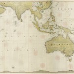
1873
[AUSTRALIA-] A General Chart of the Indian and Part of the Pacific Oceans, Shewing the Various Passages to & from China, Australia, New Zealand, &c. Carefully Constructed & Compiled from the most approved Observations and Modern Surveys, by J.S. Hobbs, F.R.G.S. Hydrog
$A 7,950 Add to cart -

1878
Atlas of Japan
$A 1,450 Add to cart -

1879
Australia
$A 1,250 Add to cart -

1881
Map of the Country Around Sydney from a Reconnaissance by Lieut. Parrott Volr. Engineers under the Instructions of Col. P. Scratchley R.E. C.M.G. and by the Authority of P.F. Adams Esq. Surveyor General N.S.W.
$A 9,500 Add to cart -

1882
Wyld’s outline Chart from England to Australia & China for the purpose of pricking off a Ship’s Track.
$A 2,750 Add to cart -

1886
Map of Burmah and the Surrounding Countries by James Wyld.
Read more -

1888
Railway Postal and Telegraph Map of New South Wales.
$A 375 Add to cart -

1897
Map of New South Wales 1897
$A 1,250 Add to cart -
![[AUSTRALIA-VIC] Entrance to Port Phillip Including the Banks and Channels](https://antiqueprintmaproom.com/wp-content/uploads/2021/03/MG_3073-copy-270x138.jpg "[AUSTRALIA-VIC] Entrance to Port Phillip Including the Banks and Channels Wall Maps")
1905
[AUSTRALIA-VIC] Entrance to Port Phillip Including the Banks and Channels
$A 1,250 Add to cart -

1909
Topographical Map of Commonwealth Territory Jervis Bay Parish of Bherwerre County of St. Vincent.
$A 1,250 Add to cart -
![[ASIA-SINGAPORE] China Sea - Singapore Road](https://antiqueprintmaproom.com/wp-content/uploads/2020/07/MG_0747-copy-179x270.jpg "[ASIA-SINGAPORE] China Sea – Singapore Road Wall Maps")
1911
[ASIA-SINGAPORE] China Sea – Singapore Road
$A 6,750 Add to cart -

1912
Map of the City of Sydney and Adjacent Municipalities 1912
$A 2,250 Add to cart -
![[ASIA-SINGAPORE] China Sea Singapore Straight](https://antiqueprintmaproom.com/wp-content/uploads/2024/07/MG_8834-270x143.jpg "[ASIA-SINGAPORE] China Sea Singapore Straight Wall Maps")
1914
[ASIA-SINGAPORE] China Sea Singapore Straight
$A 4,750 Add to cart -

1916
Royal Commission on Sydney Improvement Map Showing Main Roads which the Commission recommends should be re-Aligned and widened: the city and suburban railway proposals submitted by the chief Commissioner, and generally recommended for adoption.
$A 1,850 Add to cart -

1919
Robinson’s road, rail & tramway map of Sydney & Suburbs
$A 3,250 Add to cart -

1920
Plan shewing pastoral leases, grazing licences and pastoral permits in the Northern Territory of Australia
$A 1,350 Add to cart -

1925
Atlas-Geography of Siam / Atlas-Geographie du Siam
$A 750 Add to cart -

1945
Craigie’s Towns Map of New South Wales
$A 850 Add to cart -

1950
Japanese Globe
$A 1,250 Add to cart -

1952
General Map of Newcastle Maitland & Cessnock
$A 595 Add to cart -

1958
General Map of Sydney and Environs showing Localities, Railways, Tramways, and Principal Roads.
$A 1,350 Add to cart -

1963
Pergamon Moon Globe
$A 650 Add to cart
Showing all 42 results