Showing 1–48 of 68 results
-

1695
Carte Particuliere de L’Amerique Septentrionale, sour sont Compris Le Destroit De Davids, Le Destroit De Hudson, &s. Dressee sur les Relations les plus Nouvelles.
$A 1,250 Add to cart -

1701
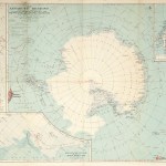
Polo Australe. Meridionale, & Antartico.
$A 1,850 Add to cart -

1710
Repraesentatio Geographica Itineris Martitimi Navis Victoriae un Qua ex Personis CC XXX VII…
$A 1,650 Add to cart -

1715
Planisphere representant toute l’etendue du monde dans l’ordre qu’on a suivi dans ce livre
$A 1,350 Add to cart -

1730
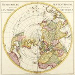
Hemisphere Septentrional pour voir plus distinctement Les Terres Arctiques.
$A 750 Add to cart -

1740
L’Hemisphere meridional pour voir plus distinctement les terres Australes
$A 750 Add to cart -

1747
De Noord Pool waar in aangetoont werd alle de Nieuwe Landen…. / De Eilanden van Sangir Sjauw eu Pangasare
$A 575 Add to cart -

1753
Representation du Cours Ordinaire des Vents de Traverse qui regment le long des Cotes dans la Mer Atlantique & celle des Indes.
$A 275 Add to cart -

1759
Tabula Geographica Hemisphaerii Borealis…
$A 725 Add to cart -

1776
Carte des deux Regions Polaires….
$A 750 Add to cart -

1777
Chart of the Discoveries made in the South Atlantic Ocean, in His Majestys Ship Resolution under the Command of Captain Cook in Jany. 1775.
$A 475 Add to cart -

1784
Kerguelen’s Land called by C. Cook Island of Desolation
$A 325 Add to cart -

1786
A map of the world in three sections, describing the polar regions to the tropics in which are traced the tracks of Lord Mulgrave and Captain Cook towards the North & South Pole and the torrid zone or tropical regions with the new discoveries in the South Sea.
$A 575 Add to cart -

1786
Hemisphere Occidental.
$A 325 Add to cart -

1791
Hémisphère Oriental ou Ancien Monde.
$A 225 Add to cart -

1800
A map of the Countries Thirty Degrees Round the North Pole.
$A 475 Add to cart -

1800
Die untere oder sudliche Halbkugel der Erde auf den horizont von Wien stereographisch entworfen von J.A. Ecker, aufs neue ; verbessert herausgegeben von P.J. Schalbacher 1800
$A 1,450 Add to cart -

1804
Mappe-monde pour indiquer la charpente des deux continents; Regions polaires comparees d’apres les derniers voyages.
$A 650 Add to cart -

1823
Southern Hemisphere.
$A 750 Add to cart -

1830
Western Hemisphere.
$A 325 Add to cart -

1838
Carte Contenant les Routes et les Reconnaissances des Corvettes L’Astrolabe et La Zelee dans les Regions Australes
$A 850 Add to cart -

1847
Carte des iles South-Orkney, Sandwich, Géorgie et d’une partie des Terres Australes dresseee par Mr. Vincendon Dumoulin
$A 850 Add to cart -
")
1854
Eastern Hemisphere.
$A 475 Add to cart -

1855
Southern Hemisphere Projected on the Plane of the Horizon of the Antipodes of London
$A 475 Add to cart -

1856
Map of the lines of equal polarization in the atmosphere constructed by Sir David Brewster
$A 195 Add to cart -

1856
Colton’s Patagonia. South Orkney or Powell’s Group. Falkland Islands. South Georgia Island.
$A 165 Add to cart -

1860
Tableau des Recions Circumpolaires ou Carte Spheroidale des deux Poles.
$A 575 Add to cart -

1860
Polar-Karte enthaltend: die Länder u. Meere vom Nord Pol bis 50° N.Br. u. weiter, mit der Übersicht des Russischen Reiches in Europa, Asia u. America.
$A 110 Add to cart -

1860
Tableau general de Thermometrie, dans les Diverses Contrees du Globe.
$A 475 Add to cart -

1860
Tableau general de Navigation, ou des routes a Travers les Ocean,….
$A 575 Add to cart -

1862
Histoire de la Decouverte des Mondes Nouveau et Inconnu.
$A 350 Add to cart -

1862
Westliche Halbrugel
$A 195 Add to cart -

1863
Oestliche Halbkugel
$A 225 Add to cart -

1863
Planiglob der Antipoden oder der grossten Entsernungen auf der Erde
$A 195 Add to cart -

1876
Amerikanischen Nordpolar-Expedition
$A 145 Add to cart -

1876
Der Entdeckuncen Der Enclischen Polar-Expedition
$A 65 Add to cart -

1876
Endgültige Karte von Franz Josef Land entdeckt von der 2. Österr-Ungar.n Nordpolar-Expedition 1873 & 1874 Aufgenommen von Julius Payer.
$A 145 Add to cart -

1877
North Polar Chart
$A 225 Add to cart -

1877
Original Karte der Ruckreise der Osterr.-Ungar Expedition Mai-August 1874. Nach Weyprecht’s Beobachtungen.
$A 75 Add to cart -

1878
South Polar Regions
$A 155 Add to cart -

1887
X. Die Sudpolarlander.
$A 75 Add to cart -

1890
South Polar Regions.
$A 165 Add to cart -

1895
Karten zur Geschichte der Geograpie. I.
$A 90 Add to cart -

1895
South Polar Regions
$A 125 Add to cart -

1895
Karte der Sudpolarlander
$A 145 Add to cart -

1895
Western and Eastern Hemispheres
$A 275 Add to cart -

1895
Karte der Sudpolarforfchungen.
$A 110 Add to cart -

1897
Icebergs in the Southern Ocean No. 2 1895 6 & 7
$A 325 Add to cart
Showing 1–48 of 68 results