


Showing 529–576 of 724 results
-

1900
Buenos-Aires.
$A 110 Add to cart -

1900
Budapest.
$A 75 Add to cart -

1900
Dublin.
$A 75 Add to cart -

1900
Australia and Tasmania
$A 225 Add to cart -

1900
Town Lots Auction Sale Crown Lands Port Hacking on Tuesday 10th.. April 1900 at 11-30 o’clock a.m. Plan of the Village of Gunn Amatta Parish of Sutherland County of Cumberland Land District Liverpool…
$A 1,150 Add to cart -
 Town Plans")
1900
Munchen (Munich)
$A 85 Add to cart -

1900
Neapel.
$A 110 Add to cart -
![[AUSTRALIA-WA] Mary Anne Passage and Approaches Surveyed by Commander J.W. Combe, R.N.](https://antiqueprintmaproom.com/wp-content/uploads/2021/03/MG_2533-copy-185x270.jpg "[AUSTRALIA-WA] Mary Anne Passage and Approaches Surveyed by Commander J.W. Combe, R.N. Western Australia")
1901
[AUSTRALIA-WA] Mary Anne Passage and Approaches Surveyed by Commander J.W. Combe, R.N.
$A 950 Add to cart -

1901
Religions of the World
$A 110 Add to cart -

1901
Manila and Cavite Anchorages Manila Bay.
$A 425 Add to cart -

1901
Water Supply Department – Map of Queensland Showing Positions, Depths, Flows, &c. of Artesian Borings 1901
$A 575 Add to cart -

1901
Edinburgh.
$A 65 Add to cart -

1901
Breslau.
$A 110 Add to cart -
![[SOUTH AMERICA] Cape dos Bahias to Staten Island](https://antiqueprintmaproom.com/wp-content/uploads/2023/11/MG_8761-Web-176x270.jpg "[SOUTH AMERICA] Cape dos Bahias to Staten Island Americas")
1901
[SOUTH AMERICA] Cape dos Bahias to Staten Island
$A 650 Add to cart -

1902
British Isles – Railways.
$A 145 Add to cart -

1902
Commercial Chart of the Far East.
$A 225 Add to cart -
![[AUSTRALIA-WA] Cape Le Grand to Cape Pasley with part of the Archipelago of the Recherche surveyed by Commander J.W.Combe. R.N.](https://antiqueprintmaproom.com/wp-content/uploads/2020/06/mg_7581_copy_1-270x186.jpg "[AUSTRALIA-WA] Cape Le Grand to Cape Pasley with part of the Archipelago of the Recherche surveyed by Commander J.W.Combe. R.N. Western Australia")
1902
[AUSTRALIA-WA] Cape Le Grand to Cape Pasley with part of the Archipelago of the Recherche surveyed by Commander J.W.Combe. R.N.
$A 750 Add to cart -

1902
Commercial Chart of North Atlantic.
$A 145 Add to cart -
![[AUSTRALIA-VIC] Port Phillip to Gabo Island Compiled from the Latest Admiralty Surveys](https://antiqueprintmaproom.com/wp-content/uploads/2020/06/mg_7587_copy_1-270x184.jpg "[AUSTRALIA-VIC] Port Phillip to Gabo Island Compiled from the Latest Admiralty Surveys New South Wales")
1902
[AUSTRALIA-VIC] Port Phillip to Gabo Island Compiled from the Latest Admiralty Surveys
$A 650 Add to cart -

1903
London and Vicinity.
$A 195 Add to cart -

1903
England and Wales Section VI. Hereford, Monmouth, Gloucester, Somerset,….
$A 50 Add to cart -

1903
India, Southern Part.
$A 195 Add to cart -

1903
Wien, Stadtgebiet.
$A 85 Add to cart -

1903
Wilhelmshaven
$A 40 Add to cart -

1903
Newcastle Harbour – Shewing Proposed Improvements.
$A 375 Add to cart -

1903
Newcastle Harbour – Shewing Proposed Improvements.
$A 375 Add to cart -

1903
Washington
$A 55 Add to cart -

1903
England and Wales, Southern Part.
$A 50 Add to cart -

1903
England Section III. Nottingham, Leicester, Rutland, Northampton, Huntingdon, Cambridge, Norfolk, Suffolk…..
$A 50 Add to cart -

1904
Tokio.
$A 110 Add to cart -

1904
Geological Sketch Map N01 & 02 of Arrino Yandanooka Mining District
$A 125 Add to cart -

1904
Potsdam und Umgebung.
$A 40 Add to cart -

1904
Rom und Umgebung
$A 75 Add to cart -

1904
Map of the Central Goldfields including parts of Murchison, East Murchison, Yalgoo. & Peak Hill C.f.s.
$A 650 Add to cart -

1904
Bordeaux.
$A 110 Add to cart -

1904
Map of Portion of Phillips River Goldfield
$A 275 Add to cart -

1905
General Plan Shewing the Principal Workings of the Menzies Group of Mines.
$A 325 Add to cart -

1905
8907 Reserve for Explosives 327 Acres
$A 125 Add to cart -

1905
Map of Western Australia Shewing the Geological Maps Issued since 1896
$A 450 Add to cart -
![[AUSTRALIA-VIC] Entrance to Port Phillip Including the Banks and Channels](https://antiqueprintmaproom.com/wp-content/uploads/2021/03/MG_3073-copy-270x138.jpg "[AUSTRALIA-VIC] Entrance to Port Phillip Including the Banks and Channels Wall Maps")
1905
[AUSTRALIA-VIC] Entrance to Port Phillip Including the Banks and Channels
$A 1,250 Add to cart -

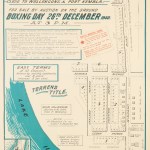
1905
Pittwater Green Point Estate
$A 325 Add to cart -

1905
Royal Commission on the Cataract Dam, Sydney Water Supply.
$A 525 Add to cart -

1905
Portsmouth und Southampton
$A 45 Add to cart -

1906
Plan Shewing Subdivision of Part of Grant of 90 ac to Nicholas Devine 8th Oct. 1799-Parish of Petersham. County of Cumberland-
$A 650 Add to cart -

1906
Melbourne Harbour Trust General Plan Shewing River and Harbor Improvements
$A 1,750 Add to cart -

1906
Geological Map of the Kimberley District Western Australia……
$A 550 Add to cart -

1906
Map of the Town of Lismore. Showing the places at which PLAGUE-infected Rodents were taken in 1905…..
$A 850 Add to cart -
![[Plague] Map of the Town of Ballina. Showing the places at which PLAGUE-infected Rodents were taken in 1905.....](https://antiqueprintmaproom.com/wp-content/uploads/2020/07/mg_0665_copy_1-270x209.jpg "[Plague] Map of the Town of Ballina. Showing the places at which PLAGUE-infected Rodents were taken in 1905….. Town Plans")
1906
[Plague] Map of the Town of Ballina. Showing the places at which PLAGUE-infected Rodents were taken in 1905…..
$A 850 Add to cart
Showing 529–576 of 724 results