Posted on

Abraham Ortelius: Creator of the First Modern Atlas

Abraham Ortelius: Creator of the First Modern Atlas

Abraham Ortelius (1527–1598) is celebrated as one of the most important figures in the history of cartography. A Flemish mapmaker, geographer, and dealer in prints, Ortelius revolutionised the way the world was visualised with the publication of his Theatrum Orbis Terrarum in 1570, regarded as the first modern atlas. His work transformed mapmaking from a craft of individual sheets into a comprehensive, systematic presentation of global geography.

Early Life and Career
Ortelius was born in Antwerp, then a flourishing centre of trade, learning, and printing in the Spanish Netherlands. Trained as a map illuminator and engraver, he began his career selling books, prints, and maps at fairs across Europe. This exposure gave him a wide knowledge of geographic sources and established contacts with other cartographers, notably Gerard Mercator, whose friendship and influence were decisive. Ortelius combined an entrepreneurial spirit with scholarly curiosity, collecting maps from across Europe and considering ways to standardise and harmonise them.

Theatrum Orbis Terrarum (1570)
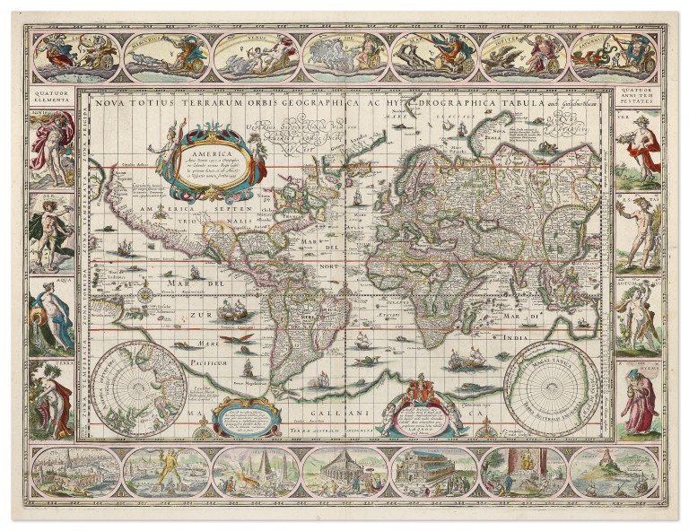
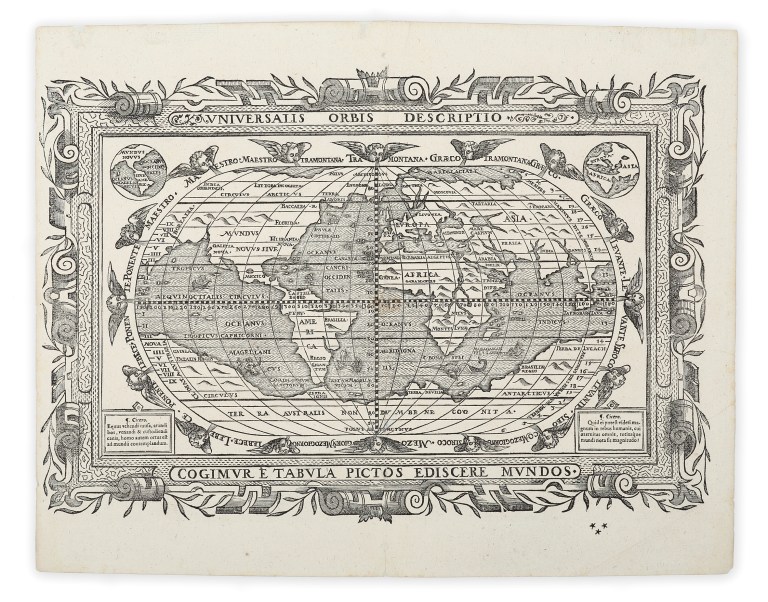
In 1570 Ortelius issued the Theatrum Orbis Terrarum (“Theatre of the World”), a landmark in the history of cartography. Unlike earlier collections, which were often loosely assembled, Ortelius’s atlas offered a uniform set of maps printed to a consistent format, accompanied by explanatory text. The first edition contained 53 maps engraved by Frans Hogenberg, covering the known continents and major regions. Its success was immediate: new editions followed rapidly, translated into Latin, Dutch, French, German, Spanish, and Italian, making it one of the most widely circulated scientific works of its time.

Over the course of four decades, the Theatrum expanded to include more than 150 maps, drawn from the best sources available. Ortelius scrupulously credited his contributors in a section titled Catalogus Auctorum — an unprecedented bibliography of mapmakers. In this way, he acknowledged the collaborative nature of cartographic knowledge and preserved the names of more than eighty geographers whose work might otherwise have been lost.

Innovation and Vision
Ortelius’s atlas not only standardised cartographic presentation but also fostered a sense of global unity, showing the earth as a connected whole. His maps balanced geographic accuracy with rich decoration: allegorical figures, sea monsters, ships, and elaborate borders reflected the artistic tastes of the Renaissance while engaging the viewer’s imagination.

Ortelius was also intellectually adventurous. In his 1596 edition of the Theatrum, he speculated that the continents had once been joined and later drifted apart — an early anticipation of modern plate tectonics. Such ideas reveal his curiosity about natural processes and his willingness to move beyond received tradition.

Legacy
By the time of his death in 1598, Ortelius’s Theatrum Orbis Terrarum had established itself as the definitive atlas of its era. It influenced generations of mapmakers and set a template for the atlas as a genre, combining accuracy, accessibility, and visual splendour. Today, Ortelius is remembered not only as a skilled geographer but also as a cultural figure of the Renaissance, whose maps blended science, art, and humanist scholarship.

Through the Theatrum, Ortelius gave his contemporaries — and posterity — a new way to comprehend the world: orderly, unified, and profoundly imaginative.

Posted on

The Blaeu Mapmaking Family​​

The Blaeu Mapmaking Family​

The Blaeu Mapmaking Family

Few names in the history of cartography carry as much prestige as the Blaeu family of Amsterdam. Active during the Dutch Golden Age, the Blaeus elevated mapmaking to a union of science, art, and commerce. Their atlases and wall maps not only guided merchants and explorers but also adorned the homes of wealthy patrons, symbolising knowledge and worldliness.

Origins with Willem Janszoon Blaeu (1571–1638)
The dynasty began with Willem Janszoon Blaeu, a student of the great Danish astronomer Tycho Brahe. Trained in astronomy and instrument making, Willem combined technical precision with a craftsman’s skill. Establishing his workshop in Amsterdam around 1596, he produced globes, instruments, and some of the earliest printed sea charts. His work reflected both navigational practicality and aesthetic refinement, with elaborate decorative cartouches, coats of arms, and allegorical figures enhancing geographic information. In 1633, Willem was appointed the official cartographer of the Dutch East India Company (VOC), giving his firm privileged access to the latest geographical discoveries from around the globe.

Joan and Cornelis Blaeu
After Willem’s death in 1638, his sons Joan (1596–1673) and Cornelis (1610–1648) inherited the business. Cornelis worked closely with Joan but died relatively young, leaving Joan to carry forward the family’s legacy. Under his direction, the Blaeu press expanded dramatically, producing wall maps, city plans, and above all, atlases of unprecedented scope.

The Atlas Major
The pinnacle of the Blaeu family’s achievements was the Atlas Major, first published in Latin between 1662 and 1672. This monumental work, comprising up to twelve volumes and nearly 600 maps, was the most ambitious atlas of the 17th century. It covered not only the continents and seas but also included detailed maps of individual regions, cities, and provinces. The Atlas Major was as much a work of art as of geography: the maps were engraved with extraordinary finesse, richly hand-coloured, and adorned with vignettes of ships, mythological figures, and local scenes. Copies were prized by princes, scholars, and collectors across Europe, symbolising the reach of Dutch commerce and learning.

Scientific and Artistic Significance
The Blaeus embodied the Dutch cartographic tradition’s balance between accuracy and ornament. Their maps drew upon the latest reports from VOC voyages, astronomers, and surveyors, ensuring geographic credibility. At the same time, the elegance of their design made their maps objects of display as much as instruments of navigation. The family’s work exemplified the broader cultural moment of the Dutch Golden Age, when science, art, and trade were closely intertwined.

Decline and Legacy
The Blaeu enterprise came to an abrupt end in 1672, when a devastating fire destroyed the family’s printing house and much of their stock. Joan Blaeu, already weakened by age and illness, died the following year. Despite this tragic conclusion, the Blaeus’ influence endured. Their atlases and wall maps remained in use long after, and their visual style shaped European mapmaking well into the 18th century.

Today, the name Blaeu evokes both scientific achievement and artistic splendour. Their maps are celebrated not only for the geographic knowledge they convey but also for their enduring beauty, making them among the most sought-after treasures of early modern cartography.

Posted on

John Gould

John Gould

John Gould: The Bird Man of the Nineteenth Century

John Gould (1804–1881) was one of the most influential ornithologists and natural history publishers of the Victorian era. Renowned as the “Bird Man,” he combined scientific ambition with entrepreneurial flair, producing lavishly illustrated works that brought the beauty and diversity of the world’s avifauna to a broad audience.

Early Life and Career
Born in Lyme Regis, Dorset, Gould was the son of a gardener. His early training as a taxidermist sharpened his observational skills and gave him a practical grounding in natural history. In 1827, he was appointed curator and taxidermist to the Zoological Society of London, a position that placed him at the centre of Britain’s scientific community. There he encountered newly arrived bird specimens from across the globe, sparking a lifelong ambition to document and illustrate them systematically.

Major Publications
Gould’s first major work, A Century of Birds from the Himalaya Mountains (1831–1832), set the pattern for his career. Gould collaborated with talented illustrators such as his wife Elizabeth Coxen Gould, Edward Lear, and later Henry Constantine Richter. Gould supplied the scientific expertise, descriptions, and organisation, while his collaborators executed the exquisite hand-coloured lithographs.

Over the next five decades, Gould oversaw the production of more than 40 folio volumes comprising some 3,000 plates. Among the most famous is The Birds of Australia (1840–1848). These monumental series blended artistry and science, each plate combining detailed accuracy with visual splendour. His Australian works were particularly groundbreaking, recording hundreds of species, many previously unknown to Europeans.

Connection to Darwin
Gould also played a small but significant role in the history of evolutionary theory. In 1837, he was asked by Charles Darwin to examine bird specimens collected during the voyage of HMS Beagle. Gould’s identification of the Galápagos finches as distinct species provided crucial evidence that helped Darwin develop his ideas on natural selection.

Australia and Beyond
Gould’s ties to Australia were especially strong. In 1838 he travelled there with his wife Elizabeth, collecting specimens and observing birds in the field. This expedition provided the material for The Birds of Australia, his most celebrated work, published in seven volumes between 1840 and 1848. It remains a landmark in both Australian natural history and the art of ornithological illustration.

Legacy
John Gould’s career exemplified the Victorian appetite for natural history, where science, art, and publishing converged. His works were issued by subscription, aimed at wealthy patrons and institutions, yet their influence extended far beyond elite circles. Today, original Gould plates are prized by collectors and museums alike, admired for their technical brilliance and decorative appeal.

Though some critics note that Gould was more entrepreneur than field naturalist, his role in disseminating ornithological knowledge cannot be overstated. By harnessing the talents of gifted artists and the enthusiasm of a public eager for exotic wonders, Gould created an enduring visual archive of birdlife that continues to inspire admiration and study more than a century after his death.

Related Categories...

Posted on

The Voyages of Captain James Cook​

The Voyages of Captain James Cook

Captain James Cook (1728–1779) stands among the most significant navigators of the Age of Enlightenment, whose three great Pacific voyages reshaped European understanding of the world’s oceans and continents. His careful seamanship, scientific precision, and detailed cartography left a lasting legacy that extended from the South Pacific to the Arctic.

The First Voyage (1768–1771)
Cook’s first voyage, aboard HMS Endeavour, was commissioned by the Royal Society and the Admiralty. Its primary purpose was to observe the 1769 Transit of Venus from Tahiti, a rare astronomical event that promised to help determine the scale of the solar system. After the successful observation, Cook was ordered to search for the fabled “Great Southern Continent.” He proceeded to New Zealand, which he circumnavigated, proving it was not part of a larger landmass. He then sailed westward, charting the entire eastern coast of Australia with remarkable accuracy. On 22 August 1770, he claimed the territory for Britain under the name New South Wales. This first voyage established Cook’s reputation as a master cartographer and navigator.

The Second Voyage (1772–1775)
Cook’s second voyage, commanding HMS Resolution with HMS Adventure as consort, aimed to settle the question of the existence of Terra Australis Incognita, the vast southern continent long hypothesised by geographers. Sailing south, Cook crossed the Antarctic Circle in 1773, the first known navigator to do so. Although he did not sight Antarctica itself, his repeated southern forays demonstrated that no habitable continent existed in the temperate latitudes of the South Pacific. Along the way, he charted numerous Pacific islands, from Tonga to Easter Island, and improved European knowledge of Polynesian geography. The voyage further showcased Cook’s skill in maintaining the health of his crews, largely preventing scurvy through disciplined diet and hygiene.

The Third Voyage (1776–1779)
Cook’s final expedition sought a northwest passage between the Atlantic and Pacific. Again in Resolution, with HMS Discovery, he revisited many Polynesian islands before sailing north to the Pacific Northwest of America. He charted the coastlines of present-day British Columbia and Alaska with characteristic detail, before pressing into the Arctic. Ice ultimately forced him back. On the return journey, he visited the Hawaiian Islands, where he was initially welcomed. However, conflict arose during a later visit in 1779, and Cook was killed at Kealakekua Bay. His death marked the end of a career that had profoundly advanced geographic and scientific knowledge.

Legacy
Cook’s three voyages combined precise mapping, astronomical observation, and natural history. His charts of New Zealand, eastern Australia, and the Pacific remained authoritative for decades. He also demonstrated new standards in crew welfare and scientific cooperation, travelling with figures such as Joseph Banks and Johann Reinhold Forster. While his journeys facilitated imperial expansion, they also exemplified Enlightenment ideals of inquiry and documentation.

By the end of the 18th century, James Cook’s name had become synonymous with exploration, his voyages bridging the worlds of science, empire, and discovery, and reshaping Europe’s vision of the Pacific and beyond.

Related categories

Posted on

The Charting of Australia from the 1600s​

The Charting of Australia from the 1600s

The charting of Australia was a gradual process, unfolding over three centuries through the work of explorers, navigators, and surveyors from multiple nations. By the early 20th century, the continent’s outline, coastal hazards, and inland geography were well recorded — a far cry from the speculative forms that first appeared on European maps.

Seventeenth Century: Dutch Beginnings
The first significant European mapping of Australia came with the Dutch East India Company (VOC) in the early 1600s. In 1616, Dirk Hartog made landfall on the west coast, leaving a pewter plate as a record. Over subsequent decades, VOC captains including Jan Carstensz, Pieter Nuyts, and Gerrit Frederikszoon de Witt charted stretches of the north, west, and south coasts. Abel Tasman’s voyages of 1642 and 1644 were the most ambitious, producing maps that connected these fragments into the outline of “New Holland.” Though incomplete, these charts established the framework for future exploration.

Eighteenth Century: British and French Interest
By the 1700s, “New Holland” appeared widely in European atlases, largely from Dutch sources. The English navigator William Dampier, visiting in 1688 and 1699, added detail to parts of the west and north coasts, his reports stimulating British curiosity. In the late 18th century, scientific exploration expanded. James Cook’s first voyage (1768–1771) charted the entire east coast with remarkable precision, naming it New South Wales and claiming it for Britain. Meanwhile, French expeditions under La Pérouse and later Bruni d’Entrecasteaux contributed valuable observations, reflecting the Enlightenment spirit of shared geographic knowledge.

Early Nineteenth Century: Completing the Coastline
With the establishment of a British penal colony in 1788, accurate coastal charts became a necessity. Matthew Flinders and George Bass’s circumnavigation of Tasmania in 1798 proved it to be an island. From 1801 to 1803, Flinders undertook the first circumnavigation of the continent, producing his General Chart of Terra Australis (1814), the first map to show a nearly complete outline. At the same time, French navigator Nicolas Baudin’s expedition, with cartographer Louis de Freycinet, mapped much of the southern coast in detail, in part overlapping Flinders’ work.

Mid to Late Nineteenth Century: Hydrography and Inland Surveys
From the 1820s to the 1860s, the Royal Navy’s Hydrographic Office, aided by colonial survey departments, refined coastal charts, identifying reefs, shoals, and harbour depths critical for navigation. Phillip Parker King’s surveys filled many remaining gaps, particularly in northern waters. Inland exploration by Sturt, Mitchell, Leichhardt, and Eyre mapped river systems, mountain ranges, and desert regions, gradually integrating inland geography into broader colonial maps.

By mid-century, lithographic printing enabled faster, more economical production of maps, allowing updated charts to circulate widely among mariners, settlers, and government offices. Cadastral surveys expanded, mapping agricultural lands, mining districts, and new towns.

Related Categories

Posted on

Printing Processes of Antique Maps

Printing Processes of Antique Maps

The production of antique maps between the 15th and 19th centuries combined artistry, craftsmanship, and evolving print technologies. Understanding the printing processes not only enriches appreciation of these works but also aids in identifying period authenticity. The principal methods—woodcut, copper engraving, etching, and lithography—each left distinct visual and tactile characteristics.

Woodcut (15th–16th Century)
Woodcut printing, the earliest European mapmaking process, was prevalent during the incunabula period (pre-1500). The image was carved in relief on a hardwood block, the raised areas inked, and paper pressed onto the surface. This technique produced bold lines but limited fine detail, often requiring colour to be applied by hand for visual enhancement. Notable woodcut maps include those of Hartmann Schedel’s Nuremberg Chronicle (1493). While durable, the blocks wore down over time, sometimes softening details in later impressions.

Copperplate Engraving (16th–18th Century)
From the mid-1500s, copperplate engraving became the dominant method for high-quality cartography. The engraver incised the design into a polished copper sheet using a burin. Ink was worked into the engraved lines, the surface wiped clean, and dampened paper pressed into the incisions under high pressure. This intaglio process allowed extraordinary precision, enabling fine lettering, delicate hachuring, and elaborate decorative cartouches. Masters such as Abraham Ortelius, Gerard Mercator, and the Blaeu family elevated the copperplate to an art form. As copper wore more quickly than steel, plates were periodically re-engraved or strengthened, resulting in subtle variations between states.

Etching (17th–18th Century)
Etching offered a more fluid and painterly approach to linework. The copper plate was coated with an acid-resistant ground; the artist drew through this ground with a stylus, exposing the metal. The plate was then submerged in acid, which “bit” the exposed lines. This method required less physical force than engraving, allowing freer, more expressive lines. Many mapmakers combined etching with engraving—reserving engraving for precise lettering and etching for landscapes, figures, and decorative elements. French mapmakers of the 17th and 18th centuries often excelled in this hybrid technique.

Lithography (Early 19th Century Onwards)
Lithography marked a radical shift. Invented in 1796 by Alois Senefelder, it relied on the immiscibility of grease and water. Designs were drawn with a greasy crayon onto limestone; the stone was dampened, ink applied, and transferred to paper under pressure. Lithography could reproduce shaded areas and subtle gradations, making it particularly suited to topographical maps and later, coloured printing. Chromolithography, introduced in the mid-19th century, allowed multiple colours to be printed from separate stones, reducing the need for hand colouring and enabling commercial production at scale.

Identifying Techniques in Antique Maps
Collectors often rely on close examination with a magnifier:

Woodcut: thick, slightly irregular lines, visible wood grain in impressions.
Engraving: sharp, clean lines with slight plate indentations around the image.
Etching: softer, more varied lines, often combined with engraving.
Lithography: absence of plate marks, smooth tonal transitions.
Recognising these processes not only aids authentication but deepens appreciation of the artistry and technology behind antique maps. Each printing method represents its own era’s balance between technical capability, artistic ambition, and the growing demand for geographical knowledge.