


Showing 1–48 of 724 results
-

1572
Colonia Agrippina.
$A 1,450 Add to cart -

1582
Traiectum clara et vetus est Episcopalis Civita
$A 1,450 Add to cart -
![[Magdeburg] Magdeburgum.](https://antiqueprintmaproom.com/wp-content/uploads/2023/07/MG_7934-270x209.jpg "[Magdeburg] Magdeburgum. Germany")
1612
[Magdeburg] Magdeburgum.
$A 750 Add to cart -

1635
Novus Atlas, das ift abbildung und beschreibung von allen
$A 395 Add to cart -
![[Goa.]](https://antiqueprintmaproom.com/wp-content/uploads/2020/06/maps2-270x207.jpg "[Goa.] ASIA")
1646
[Goa.]
$A 450 Add to cart -

1648
Le Theatre du Monde ou Nouvel Atlas, Mis en lumiere par Guillaume & Jean Blaeu.
$A 325 Add to cart -
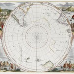
![[Den Polus Antarcticus]](https://antiqueprintmaproom.com/wp-content/uploads/2025/11/MG_1378web-270x240.jpg "[Den Polus Antarcticus] Hemispheres")
1650
[Den Polus Antarcticus]
$A 2,850 Add to cart -

1690
Table des Cartes etc Du Sr. Sanson. Contenues Dans ce Vollume.
$A 850 Add to cart -

1695
Die Fürst: Statt Stüetgart.
$A 475 Add to cart -

1719
Carte du Premier Periode du Monde Depus Adam Iusqu Oulon Voit la Chronlologie & la Genealogie des Premiers …..
$A 575 Add to cart -

1725
1. Pedemontium Florentissimum Italie Latus. 2. Sabaudia Velocis iustitiae et mauortiae virtutis anyiqua sedes
$A 1,950 Add to cart -
![[Manilhas Bay]](https://antiqueprintmaproom.com/wp-content/uploads/2021/07/MG_3713-copy-270x212.jpg "[Manilhas Bay] Town Plans")
1726
[Manilhas Bay]
$A 1,450 Add to cart -

1730
Ierusalem, cum Suburbiis Prout Tempore Christi Floruit, Accurate Notatis Omnibus Insignibus et Præcipue iis Locis, in Quibus Christus Passus est et Quæ Etiam num devota religione à Christianis coluntur juxta designationem Christiani Adrichomii delineata et æri incisa per Matthæum Seutter
$A 1,850 Add to cart -

1730
Hemisphere Septentrional pour voir plus distinctement Les Terres Arctiques.
$A 750 Add to cart -

1732
PLAN de la ville & Forteresse de LUXEMBOURG, avec la nouvelle Fortification. Mis au jour par les Heritiers d’Homann. Die Stadt u. Vestung LUXEMBURG, in einem accuraten Plan entworfen, u. zu finden in der Homaenn. Officin.
$A 975 Add to cart -

1738
Die Gegend um Nordlingen, genandt das Ries, benebst dem Prospect u. Grundris der K.Fr. Reichs St. Nordlingen……
$A 750 Add to cart -

1740
Die Hochfürstliche Residentz Friedenstein und Haupt Stadt Gotha Verfertigt und verlegt von Matthæo Seutter Irho Röm. Kajserl. Maj. Geogr. in Augsp.
$A 650 Add to cart -

1740
L’Hemisphere meridional pour voir plus distinctement les terres Australes
$A 750 Add to cart -

1742
Hemisphaerium Coeli Boreale.
$A 1,650 Add to cart -

1742
Hemisphaerium Coeli Boreale, in quo in loca Stellarum
$A 1,650 Add to cart -

1744
Guangzhou / A Plan of the City of Canton on the River Ta Ho.
$A 475 Add to cart -

1746
Plan de Madras et du Fort St Georges Pris par les Francoias le 21 September 1746.
$A 275 Add to cart -

1748
Payta / A Plan of the Town of Payta in the Kingdom of Santa-Fee Lying in the Latitude of 5d.12m.So.
$A 225 Add to cart -

1749
Plan du Fort Dauphin Construit par les Francois dans l’Isle de Madagascar.
$A 110 Add to cart -

1750
Tab. XIX
$A 975 Add to cart -

1750
Tab. XXXVIII
$A 975 Add to cart -
![[Columbia] Plan de la Ville de Carthagene des Indes](https://antiqueprintmaproom.com/wp-content/uploads/2020/07/MG_0745-copy-270x171.jpg "[Columbia] Plan de la Ville de Carthagene des Indes Town Plans")
1754
[Columbia] Plan de la Ville de Carthagene des Indes
$A 275 Add to cart -
 China")
1755
Plan de l’Enceinte de la Ville de Nan-King ou Kyang-Ning-Fou Capitale de la Province de Kyang-nan / Plan de la Ville de Su-Tcheou-Fou Cette Ville a environ 3 grandes Lieues de Tour (Nanjing)
$A 195 Add to cart -

1756
Nieuwe Kaart der platte Grond van de Stao Parys en derzelver Voorsteden…. sic
$A 850 Add to cart -

1757
Atlas Universei per M.Robert…
$A 425 Add to cart -
![Chinglapet [Chengalpattu]](https://antiqueprintmaproom.com/wp-content/uploads/2020/06/mg_0558_copy-214x270.jpg "Chinglapet [Chengalpattu] Town Plans")
1763-1778
Chinglapet [Chengalpattu]
$A 95 Add to cart -

1763-1778
Chittapet.
$A 295 Add to cart -

1763-1778
Fort St. David with the French Attack May 1758
$A 275 Add to cart -

1763-1778
A Map of the Country Extending Ten Miles to the West, and Eighteen to the East of Tritchinapoly.
$A 375 Add to cart -

1763-1778
Carangoly
$A 345 Add to cart -

1763
Thiagur
$A 225 Add to cart -

1763-1778
Trinomalee.
$A 345 Add to cart -

1763-1778
Plan of the Fronts of Fort St. George attacked by Mr. Lally from the 14th of December 1758, to the 16th of February 1759, with part of the Black Town.
$A 750 Add to cart -

1763-1778
Permacoil.
$A 325 Add to cart -

1763-1778
Palam-Cotah, near Tinivelly.
$A 295 Add to cart -
![Karical. [Karaikal]](https://antiqueprintmaproom.com/wp-content/uploads/2020/06/mg_0560_copy-217x270.jpg "Karical. [Karaikal] Town Plans")
1763-1778
Karical. [Karaikal]
$A 145 Add to cart -

1763-1778
Plan of the Attempt of the French Troops to take Tritchinapoly. by Escalade November 28 1753
$A 175 Add to cart -

1763-1778
Plan for the Intelligence of the Military Operations at Calcutta, when attacked and taken by Seerajah Dowlet 1756.
$A 1,350 Add to cart -

1764
Plan de la Ville de Boston.
$A 450 Add to cart -

1764
Plan de la Ville et Cite de St. Francois de Quito.
$A 245 Add to cart -

1764
Plan de la ville de Mongher
$A 65 Add to cart -

1764
Plan de Bombay et de ses Environs Tirc de Thornton Hyd, Ang.
$A 395 Add to cart -

1764
INDIA-Carte du District de Tranquebar.
$A 295 Add to cart
Showing 1–48 of 724 results