
Showing 1–48 of 188 results
-

17??
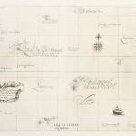
Plan de L’Ile de Paque Leve en Avril 1786 a bord des Fregates Francaises la Boussole et “Astrolabe. Plan de la Baie de Cook.
$A 475 Add to cart -

1661
Carta particolare del mare del Sur che comincia con l’Isole di Salamone e finiscie con la costa di Lima nel’Peru: la longitudino comincia da l’Isola di Pico d’Asores, Asia Carta, XXIII
$A 1,750 Add to cart -

1683
Isles de Salomon
$A 425 Add to cart -

1715
Carte ou est marquee de route que le Cap.e Dampier tint dans son Voyage depuis Timor autour de la Nouv. Bretagne
$A 275 Add to cart -

1726
Caart van het Eyland Manipa. Caart van het Eyland Noessa-Laoet. Caart van het Eyland Honimoa. Caart van het Eyland Oma.
$A 550 Add to cart -

1726
De Landvoogdy der Moluccos, met de aangrenzende Eylanden
$A 750 Add to cart -
![[Manilhas Bay]](https://antiqueprintmaproom.com/wp-content/uploads/2021/07/MG_3713-copy-270x212.jpg "[Manilhas Bay] Town Plans")
1726
[Manilhas Bay]
$A 1,450 Add to cart -
")
1742
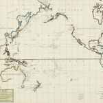
Carte Reduite Des Mers Comprises entre L’Asia et L’Amerique Apelees par les Navigateurs Mer Du Sud ou Mer Pacifique pour servir aux Vaisseaux du Roi.
$A 3,850 Add to cart -
")
1744
Carte pour Servir a l’Histoire Philosophique et Politique des Etablissemens et du Commerce des Europeens dans lex deux Indes
$A 375 Add to cart -

1748
A Plan of the Bay of Manila.
$A 575 Add to cart -
")
1753
Carte Reduite de la Mer du Sud.
$A 725 Add to cart -
")
1753
Vorftellung des Ordentlichen Strichs der Gegenwinde die an den Kuften in dem Grosen Sud Meere Regieren.
$A 245 Add to cart -

1755
Carte des Nouvelles Philippines.
$A 195 Add to cart -

1756
Charte der Papous-Inseln, zum Behus dieser Geschichte nach des Hrn. Tirions Charte Gezeichnet, von dem Hrn. Robert Vaugondy. 1756.
$A 275 Add to cart -

1764
Nouvelle des Isles Carolines.
$A 175 Add to cart -

1773
Three views of the Admiralty Isles. Joseph Freewills Islands, Current Island, St. Andrews Islands, bay at south end of Mindanao.
$A 85 Add to cart -
")
1773
Wallis’s Islands.
$A 55 Add to cart -

1773
Matavia Bay in Otaheite. Ohamaneno Harbour in Ulietea. Owharre Harbour in Huaheine. Oopoa Harbour in Ulietea.
$A 110 Add to cart -

1773
A dangerous shoal seen Septr. the 28, 1767. Joseph Freewills Islands. The south end of Mindanao.
$A 75 Add to cart -

1773
Nova Hibernia
$A 115 Add to cart -
. MAPS & GLOBES")
1773
A Chart of Captn Carteret’s Discoveries at New Britain, with part of Captn Cook’s Passage thro Endeavour Streights (sic).
$A 475 Add to cart -

1773
The North side of the largest of Queen Charlotte’s Islands, as it appeared running along shore to the Westward.
$A 65 Add to cart -

1773
Chart of the Island Otaheite, by Lieut. J. Cook 1769.
$A 525 Add to cart -
![[Cocos Island called by C. Wallis Boscawen. Traitors Island called by C. Wallis Keppel.]](https://antiqueprintmaproom.com/wp-content/uploads/2020/06/ck1_010-259x270.jpg "[Cocos Island called by C. Wallis Boscawen. Traitors Island called by C. Wallis Keppel.] Polynesia")
1773
[Cocos Island called by C. Wallis Boscawen. Traitors Island called by C. Wallis Keppel.]
$A 65 Add to cart -

1773
Queen Charlotte’s Islands.
$A 195 Add to cart -

1773
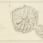
A chart and views of Pitcairns Island, latitude 25.̊02. S, long. 133.̊30 W.
$A 275 Add to cart -

1773
A Chart of the Islands Discovered in the Neighbourhood of Otaheite, in the Course of Several Voyages round the World, made by the Capt. Byron, Wallis, Carteret & Cook in the Years 1765, 1767, 1769.
$A 325 Add to cart -

1773
Chart of the Society Isles, Discovered by Lieut. J. Cook, 1769.
$A 475 Add to cart -

1774
Trois Vues des Isles de L’Amiraute./ Isles de Joseph Freewill / Trois Isles Vues….de Mindanao. / Isle du Mondrain.
$A 50 Add to cart -

1774
Cote Septentrional de la plus grande des Isles de la Reine Charlotte, tel quil nous a paru en naviguant le long de la cote e l’Ouest.
$A 75 Add to cart -
![Isles de la Reine Charlotte. [Santa Cruz Islands]](https://antiqueprintmaproom.com/wp-content/uploads/2020/06/mg_9212_copy_2-270x175.jpg "Isles de la Reine Charlotte. [Santa Cruz Islands] Melanesia")
1774
Isles de la Reine Charlotte. [Santa Cruz Islands]
$A 85 Add to cart -

1774
Isle des Cocos appellee Boscawen par le Capitaine Wallis. Isle des Traitres appellee Keppel par le Cap.ne Wallis.
$A 30 Add to cart -

1774
Matavia Bay in Otaheite. Ohamaneno Harbour in Ulietea. Owharre Harbour in Huaheine. Oopoa Harbour in Ulietea.
$A 50 Add to cart -

1774
Banc de Sable dangereux Vu le 28.Sept 1767. Isles de Jofeph Freewill. L’Extremité Méridionale de Mindanao.
$A 145 Add to cart -
")
1774
Isles de Wallis.
$A 30 Add to cart -
![Nelle Irlande.[New Ireland]](https://antiqueprintmaproom.com/wp-content/uploads/2020/06/mg_8869_copy_1-270x181.jpg "Nelle Irlande.[New Ireland] New Guinea")
1774
Nelle Irlande.[New Ireland]
$A 50 Add to cart -

1774
Carte et Vues de L’Isle Pitcairn.
$A 195 Add to cart -
")
1774
Ifle de Sir Charles Saunder, Ifle Ofnabrug, Ifle de l’Amiral Keppel, Ifle de Wallis
$A 85 Add to cart -

1777
Port Sandwich in Mallicollo, Harbour of Balade in New Caledonia , Port Resolution in the Isle of Tanna.
$A 175 Add to cart -

1777
Chart of the Friendly Isles.
$A 375 Add to cart -

1777
Harvey’s Isle. Palmerston Isle. Turtle Isle. Savage Isle.
$A 145 Add to cart -

1779
Rawak Island near Waygiou
$A 475 Add to cart -

1779
Kamaladan Harbour
$A 175 Add to cart -

1779
Sido Harbour 7 S.b. from King’s Point near Archeen.
$A 245 Add to cart -

1779
Dory Harbour on New Guinea
$A 175 Add to cart -

1779
Circular View of Ubal Harbour, on the North Part of the Island Bunwoot, near Maguindanao. at Low Water.
$A 375 Add to cart -

1779
Part of Batchian Island. Piapis Harbour. Offak Harbour.
$A 285 Add to cart -

1779
Part of Mysol Island.
$A 285 Add to cart
Showing 1–48 of 188 results