
Showing 193–240 of 518 results
-

1807
Vue de la partie meridionale de la ville de Sydney, capitale des colonies anglaises aux terres australes et de l’embouchure de la riviere de Parramatta
$A 4,750 Add to cart -

1807
Carte de la Baie des Chiens-Marins
$A 950 Add to cart -

1807
Terre De Diemen. Ouriaga.
$A 425 Add to cart -

1807
Carte d’une Partie de la Cote Orientale de la Terre de Diemen.
$A 175 Add to cart -

1807
Terre De Diemen. Bara-Ourou.
$A 375 Add to cart -

1807
Carte Generale de la Partie Sud-Est de la Terre Diemen d’apres les travaux
$A 850 Add to cart -
![[Timor] Ile Timor. Vue d'un Cimetiere Malais, d'une partie de la Baie et de la Ville Coupang, de Ile Simao et de Ile Kera.](https://antiqueprintmaproom.com/wp-content/uploads/2020/07/MG_0740-copy-2-270x222.jpg "[Timor] Ile Timor. Vue d’un Cimetiere Malais, d’une partie de la Baie et de la Ville Coupang, de Ile Simao et de Ile Kera. Baudin & Freycinet")
1807
[Timor] Ile Timor. Vue d’un Cimetiere Malais, d’une partie de la Baie et de la Ville Coupang, de Ile Simao et de Ile Kera.
$A 125 Add to cart -

1807
Timor. Peche et Navigation.
$A 165 Add to cart -

1807
Timor. Peignes Malais et Appareil Pour le Betel.
$A 145 Add to cart -

1807
Nouvelle-Hollande: Terre de Witt, Nos. 1,a,5. Terre de Diemen du Nord, Nos.6 et 7.
$A 350 Add to cart -

1807
Nouvelle-Hollande: Terre d’Endracht. Cabanes des naturels de la Presqu’ile Peron
$A 425 Add to cart -

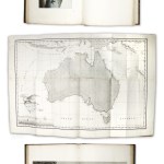
1807
Carte Generale De La Nouvelle Hollande No. 1
$A 8,750 Add to cart -

1807
Esquisse des Iles De L’Institut par M.L. Freycinet 1803.
$A 245 Add to cart -

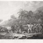
1807
Norou-Gai-Derri s’avancant pour combattre.
$A 575 Add to cart -

1807
Timor. Habitations Malaises
$A 150 Add to cart -

1807
Nouvelle Hollande. Y-Erran-Gou-La-Ga.
$A 875 Add to cart -

1807
Terre De Diemen. Paraberi.
$A 375 Add to cart -

1808
View of a Man, his Wife and child.
$A 125 Add to cart -
 Baudin & Freycinet")
1808
Plan du comte de Cumberland (Nouvelle-Galles du sud)
$A 475 Add to cart -

1808
Naba-Leba Roi DE Ile Solor.
$A 245 Add to cart -
![The Resolution beating through the ice, with the Discovery in the most eminent danger in the distance [sic]](https://antiqueprintmaproom.com/wp-content/uploads/2024/12/MG_9458web-270x196.jpg "The Resolution beating through the ice, with the Discovery in the most eminent danger in the distance [sic] ARCTIC & ANTARCTICA")
1809
The Resolution beating through the ice, with the Discovery in the most eminent danger in the distance [sic]
$A 3,500 Add to cart -
 17 Baudin & Freycinet")
1811
Carte d’une partie de la Terre Napoleon, ( a la Nouvelle Hollande.) 17
$A 1,850 Add to cart -

1813
Smoking Out the Opossum.
$A 375 Add to cart -

1816
Menschen aus Van-Diemens Land.
$A 125 Add to cart -

1821
J. Cook
$A 275 Add to cart -

1823
Abitatori della Terra di Diemen
$A 145 Add to cart -

1823
Abitatori della Nuova Olanda
$A 145 Add to cart -

1824
Phisique. Thermobatometre ou Appareil pour mesurer la temperature de la mer a de grandes Profondeurs
$A 145 Add to cart -

1824
Timor. Canda Jeune fille Malaise.
$A 350 Add to cart -

1825
Nlle. Hollande Port-Jackson Sauvages des Montagnes-bleues.
$A 350 Add to cart -

1825
Nlle. Hollande Port-Jackson Sauvages des Montagnes-bleues. 1. Hara-o; 2. Karadra.
$A 245 Add to cart -
 1. Patel 2. Yalepoul son fils 3.4. Naturels qui vinrent a bord les premiers 5. Patel II 6. Mokore. First Nations History")
1833
Nelle. Hollande. (Port du Roi Georges.) 1. Patel 2. Yalepoul son fils 3.4. Naturels qui vinrent a bord les premiers 5. Patel II 6. Mokore.
$A 300 Add to cart -

1833
Nlle Zelande Nlle Hollande
$A 300 Add to cart -

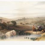
1834
Confluent du Murray et du Darling
$A 125 Add to cart -

1835
Captain Cook.
$A 115 Add to cart -

1836
Neu-Holland. Neu-Seeland
$A 110 Add to cart -

1836
Neu-Holland. 1.2.3. Frauen von der Kanguruhinsel. 4.5. Eingeborne die zuerst an Bord kamen. 6.Beam. 7.Djacamel aus Port Jervis. 8.Patel. 9. Mokore
$A 150 Add to cart -

1836
Neu-Holland. Eingeborne von Konig Georgs – Heafen u der Jervis Bay.
$A 150 Add to cart -
![Bewohner von Van Diemens Land. [1. Paraberi. 2. Ouriaga.]](https://antiqueprintmaproom.com/wp-content/uploads/2020/06/mg_0346_copy-188x270.jpg "Bewohner von Van Diemens Land. [1. Paraberi. 2. Ouriaga.] First Nations History")
1836
Bewohner von Van Diemens Land. [1. Paraberi. 2. Ouriaga.]
$A 110 Add to cart -
![Bewohner von Van Diemens Land. [1. Grou-Agara.. 2. Arra-Maida.]](https://antiqueprintmaproom.com/wp-content/uploads/2020/06/mg_0345_copy-187x270.jpg "Bewohner von Van Diemens Land. [1. Grou-Agara.. 2. Arra-Maida.] ABORIGINES")
1836
Bewohner von Van Diemens Land. [1. Grou-Agara.. 2. Arra-Maida.]
$A 110 Add to cart -

1837
Baie Jervis. Naturales mangeant du poisson vivant.
$A 65 Add to cart -
 First Nations History")
1837
Tetes et Groupe de Sauvages du Camden-Shire (Nouvelle Galles Meridionale)
$A 350 Add to cart -

1838
Head Cut in Sandstone Rock.
$A 165 Add to cart -

1838
Supposed Native Tombs discovered on the N.W. Coast of New Holland. 7th April 1838.
$A 125 Add to cart -

1839
Naturels de la Tasmanie pechant des Coquillage.
$A 90 Add to cart -

1839
Sepulture des Naturels des l’Australie.
$A 65 Add to cart -

1839
Pirogue en ecorce cousue.
$A 85 Add to cart -

1839
Village a la Baie Jervis.
$A 110 Add to cart
Showing 193–240 of 518 results