Showing 1–48 of 410 results
-
")
Enlevement du Canot de L’Astrolabe par les Naturels de Tonga Tabou
$A 550 Add to cart -

1724
Nova Guinea
$A 550 Add to cart -

1748
A View of the N W Side of Saypan one of the Ladrones or Marian Islands.
$A 275 Add to cart -

1748
A View of the Ladrone Islands.
$A 155 Add to cart -

1748
A View of the S.W. Side of Tenian.
$A 275 Add to cart -

1748
A View of the anchoring place at Tenian where the Centurion water’d.
$A 295 Add to cart -

1759
Habitans de Moa, Jamna, et Autres Isles
$A 145 Add to cart -
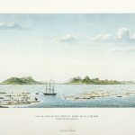
![[A View of Matavai Bay in Otaheite from One Tree Hill.]](https://antiqueprintmaproom.com/wp-content/uploads/2020/06/108-270x216.jpg "[A View of Matavai Bay in Otaheite from One Tree Hill.] Captain Cook")
1773
[A View of Matavai Bay in Otaheite from One Tree Hill.]
$A 245 Add to cart -
![[A Representation of the Surrender of the Island of Otaheite to Captain Wallis by the Supposed Queen Oberea.]](https://antiqueprintmaproom.com/wp-content/uploads/2020/06/img_20200214_124728_-270x193.jpg "[A Representation of the Surrender of the Island of Otaheite to Captain Wallis by the Supposed Queen Oberea.] PACIFIC")
1773
[A Representation of the Surrender of the Island of Otaheite to Captain Wallis by the Supposed Queen Oberea.]
$A 275 Add to cart -
![[A Military Gorget worn in the South Sea Islands.]](https://antiqueprintmaproom.com/wp-content/uploads/2020/06/097_web_a-223x270.jpg "[A Military Gorget worn in the South Sea Islands.] Captain Cook")
1773
[A Military Gorget worn in the South Sea Islands.]
$A 85 Add to cart -
![[Tools etc from the South Sea Isles]](https://antiqueprintmaproom.com/wp-content/uploads/2020/06/099_web_a-212x270.jpg "[Tools etc from the South Sea Isles] Captain Cook")
1773
[Tools etc from the South Sea Isles]
$A 110 Add to cart -
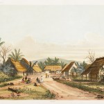
![[A view in the island of Huaheine; with the Ewharra no Eatua, or House of God]](https://antiqueprintmaproom.com/wp-content/uploads/2020/06/100_web-270x152.jpg "[A view in the island of Huaheine; with the Ewharra no Eatua, or House of God] Captain Cook")
1773
[A view in the island of Huaheine; with the Ewharra no Eatua, or House of God]
$A 150 Add to cart -

1773
[A view in the island of Otaheite; with the house or shed called tupapow, under which the dead are deposited, and a representation of the person who performs the principal part in the funeral ceremony in his peculiar dress; with a man climbing the bread-f
$A 145 Add to cart -
![[A View of the inside of a house in the island of Ulietea (Raiatea), with the representation of a dance to the music of the country.]](https://antiqueprintmaproom.com/wp-content/uploads/2020/06/104a_copy-270x184.jpg "[A View of the inside of a house in the island of Ulietea (Raiatea), with the representation of a dance to the music of the country.] Captain Cook")
1773
[A View of the inside of a house in the island of Ulietea (Raiatea), with the representation of a dance to the music of the country.]
$A 125 Add to cart -
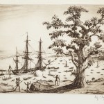
![[A View of the Island of Ulietea, with a double canoe and a boathouse.]](https://antiqueprintmaproom.com/wp-content/uploads/2020/06/103-270x130.jpg "[A View of the Island of Ulietea, with a double canoe and a boathouse.] Captain Cook")
1773
[A View of the Island of Ulietea, with a double canoe and a boathouse.]
On Hold Read more -

1773
Three views of the Admiralty Isles. Joseph Freewills Islands, Current Island, St. Andrews Islands, bay at south end of Mindanao.
$A 85 Add to cart -
![[Fly flaps South Sea Isles]](https://antiqueprintmaproom.com/wp-content/uploads/2020/06/MG_0712web-221x270.jpg "[Fly flaps South Sea Isles] Captain Cook")
1773
[Fly flaps South Sea Isles]
$A 110 Add to cart -

1773
A dangerous shoal seen Septr. the 28, 1767. Joseph Freewills Islands. The south end of Mindanao.
$A 75 Add to cart -
![[Tools and Instruments from the Society Islands.]](https://antiqueprintmaproom.com/wp-content/uploads/2020/06/111a_copy-270x218.jpg "[Tools and Instruments from the Society Islands.] Captain Cook")
1773
[Tools and Instruments from the Society Islands.]
$A 110 Add to cart -

1773
Native implements, Otaheite.
$A 40 Add to cart -

1773
Nova Hibernia
$A 115 Add to cart -

1773
Sir Charles Saunders Island. Osnaburg Island. Boscawens Island. Adml. Keppels Island. Wallis’s Island. TONGA
$A 40 Add to cart -

1774
Vue de I’Ifle d’Huaheine avec La Maison de Dieu, et un petit Autel couvert d’offrandes.
$A 90 Add to cart -

1774
Omai a Native of Ulaietea, Brought into England in the Year 1774, by Tobias Furneaux Esqr. Commander of his Majesty’s Sloop Adventure; Humbly Inscribed to the Right Honble. John Earl of Sandwich.
$A 7,500 Add to cart -

1774
Le Captaine Wallis est Attaque dans Le Dauphin par les Otahitiens.
$A 195 Add to cart -

1774
Instruments des Insulaires de la Mer du Sud.
$A 40 Add to cart -

1774
Instruments des Insulaires de la Mer du Sud.
$A 40 Add to cart -

1774
Isle de Sir Charles Saunder. Isle Osnabrug. Isle de l’Amiral Keppel. Isle de Wallis.
$A 85 Add to cart -

1774
Trois Vues des Isles de L’Amiraute./ Isles de Joseph Freewill / Trois Isles Vues….de Mindanao. / Isle du Mondrain.
$A 50 Add to cart -

1774
Maniere dont expose les morts a Otahiti.
$A 90 Add to cart -

1774
Haufe-Col Militaire des Infulaires de la Mer du Sud.
$A 40 Add to cart -

1774
Vue de la Baye de Matavaie Otahitu appellee Havre du Port Royal par le Capitaine Wallis.
$A 65 Add to cart -

1777
View in the Island of New Caledonia.
$A 275 Add to cart -

1777
Man of New Caledonia
$A 175 Add to cart -

1777
A Draught Plan and Section of the Britannia Otehite War Canoe, Shewing the Plan. sic
$A 145 Add to cart -

1777
Woman of New Caledonia.
$A 145 Add to cart -
![[Ornaments, weapons at New Caledonia.]](https://antiqueprintmaproom.com/wp-content/uploads/2020/06/072_web_a_1-270x164.jpg "[Ornaments, weapons at New Caledonia.] Captain Cook")
1777
[Ornaments, weapons at New Caledonia.]
$A 145 Add to cart -

1777
Man of the Island of Mallicolo.
$A 110 Add to cart -

1777
Afia-Too-Ca, a Burying Place in the Isle of Amsterdam.
$A 150 Add to cart -
![[Weapons, &c at Mallicollo and Tanna.]](https://antiqueprintmaproom.com/wp-content/uploads/2020/06/153_copy-221x270.jpg "[Weapons, &c at Mallicollo and Tanna.] Captain Cook")
1777
[Weapons, &c at Mallicollo and Tanna.]
$A 110 Add to cart -

1777
A Draught Plan & Section of an Amsterdam canoe, seen in the South Seas; Shewing two in the plan……
$A 150 Add to cart -
 Captain Cook")
1777
The Landing at Erramanga one of the New Hebrides. (Eromanga)
$A 675 Add to cart -

1777
Ornaments and Weapons at the Marquesas, thus marked.
$A 110 Add to cart -

1777
The Landing at Mallicolo, one of the New Hebrides.
$A 525 Add to cart -

1777
A View in the Island of Rotterdam.
$A 150 Add to cart -

1777
Man of Easter Island.
$A 195 Add to cart -

1777
View in the Island of New Caledonia
$A 525 Add to cart -

1777
Woman of Easter Island.
$A 125 Add to cart
Showing 1–48 of 410 results